XiaNaphryz
LATIN, MATRIPEDICABUS, DO YOU SPEAK IT
Some awesomely stunning work.

Earth From Above comes to NYC
Photographer Yann Arthus-Bertrand will bring his work back to the United States - to New York City for the first time in 2009. Aiming to inspire people to think globally about sustainable living, Arthus-Bertrand has been photographing unique views of our planet, seen from the sky, since 1994 - and has produced an exhibit of over 150 4-ft. by 6-ft. prints which will be on display in New York City at the World Financial Center Plaza and along the Battery Park City Esplanade from May 1, 2009 to June 28, 2009. When completed in New York City, the Earth From Above exhibit will also move on to California in 2010. Photographs and captions all courtesy of Yann Arthus-Bertrand.
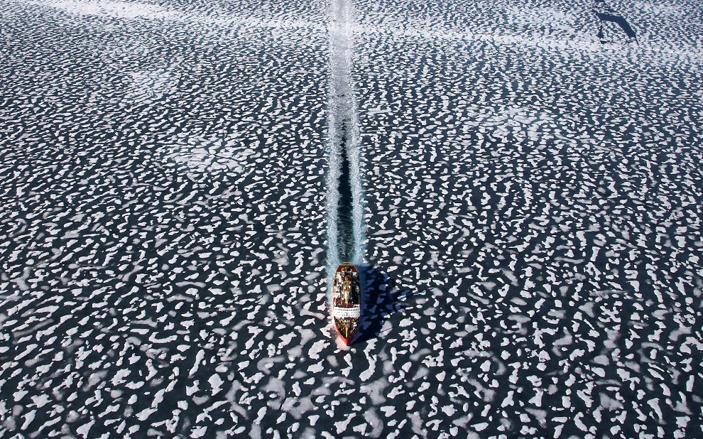
Icebreaker Louis Saint Laurent in Resolute Bay, Nunavut Territory, Canada.
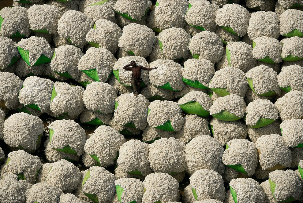
Worker resting on bales of cotton, Thonakaha, Korhogo, Ivory Coast. Cotton crops occupy approximately 335,000 square klilometers worldwide, and use nearly one quarter of all pesticides sold.
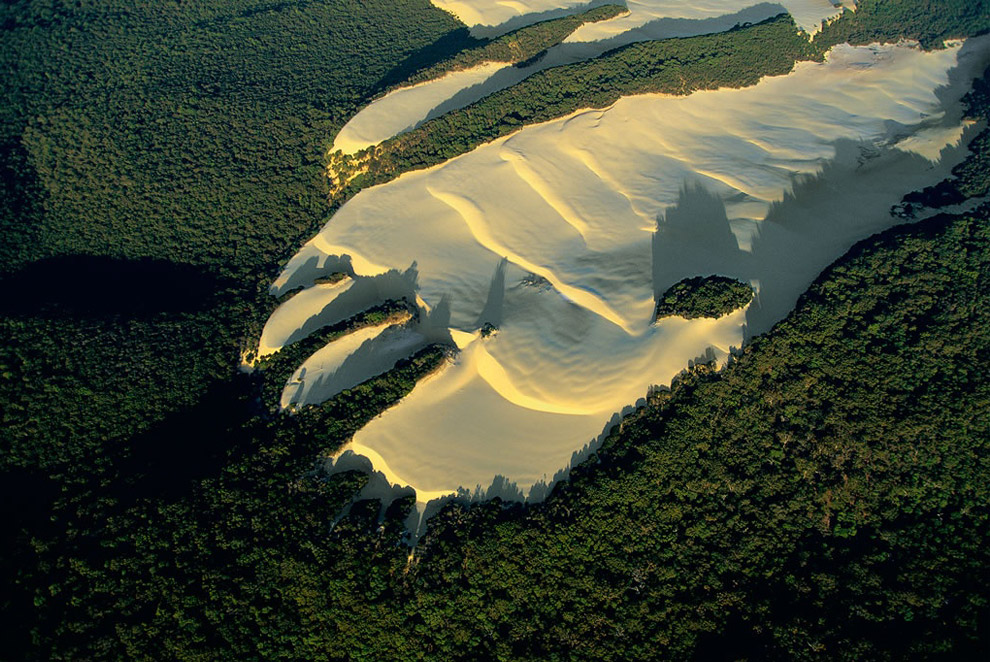
Sand dune in the heart of vegetation on Fraser island, Queensland, Australia. Fraser Island, named after Eliza Fraser, who was shipwrecked on the island in 1836, is the world's largest sand island. On top of this rather infertile substratum, a humid tropical forest has developed in the midst of which wide dunes intrude, moving with the wind. Fraser Island has important water resources, including nearly 200 freshwater dune lakes, and has varied fauna such as marsupials, birds, and reptiles. Welcoming 200,000 visitors a year without damaging the local fauna and flora is a real challenge to sustainable development on the island, which was declared a World Heritage site by Unesco in 1992.
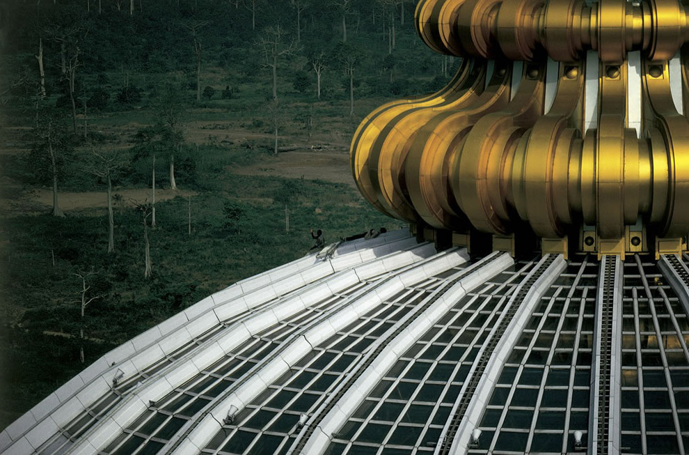
The Notre-Dame-de-la-Paix basilica in Yamoussoukro, Ivory Coast. In 1983, Yamoussoukro replaced Abidjan as the official capital of Ivory Coast. President Félix Houphouët-Boigny, who died in 1993, made his native village into a modern city with a grid of wide avenues - which are almost deserted - and every modern facility: international airport, luxury hotels, golf course, prestigious universities, and so forth. Yamoussoukro also boasts the world's biggest basilica, Notre-Dame-de-la-Paix (Our Lady of Peace), consecrated by Pope John Paul II in 1990. The former president, who donated this building to the Vatican, insisted that he had financed the basilica's cost out of his own personal fortune. This building was seen as a colossal waste by many Ivorians. It was highly controversial in a country that lacks schools and hospitals and has only nine doctors for every 100,000 inhabitants (compared to 413 in Norway).
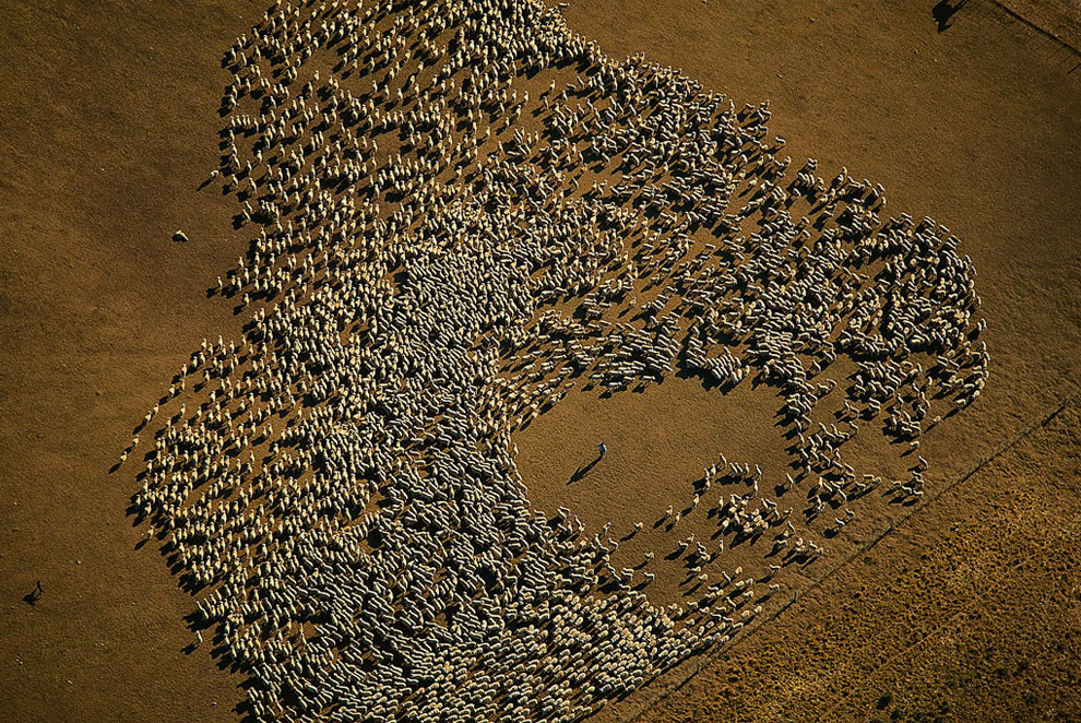
Flock of sheep, Tierra del Fuego, Argentina. After the missionary period, between gold fever and the first drillings for oil, sheep-raising became the chief activity in the north of the main island, Isla Grande de Tierra del Fuego. The local cabanas (sheep pastures) are huge sheep farms with 3.5 acres of land per head of livestock.
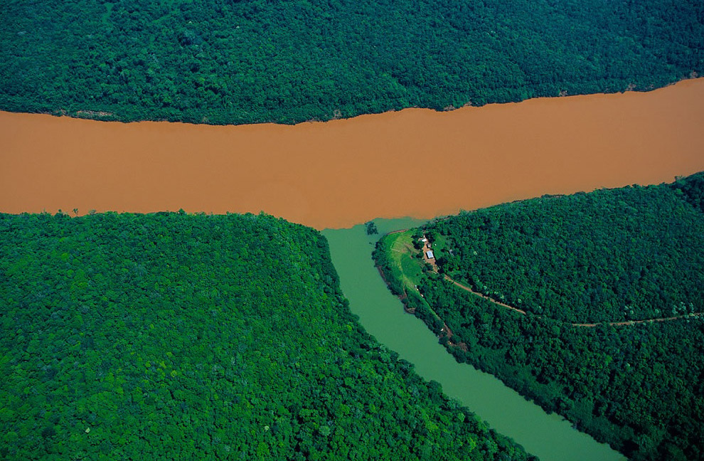
Confluence of the Rio Uruguay and a tributary, Misiones province, Argentina. Drastically cleared to make way for farming, the tropical rainforest of Argentina is now in some areas a less effective defense against erosion than it was in the past. The heavy rains in the province of Misiones (79 inches, per year) wash the soil and carry off significant quantities of iron-rich earth into the Rio Uruguay, turning the waters a dark, reddish color. Carried by the river, this sediment is dumped in the estuary of the Rio de la Plata - the largest on Earth - and accumulates in the access channels to the port of Buenos Aires.
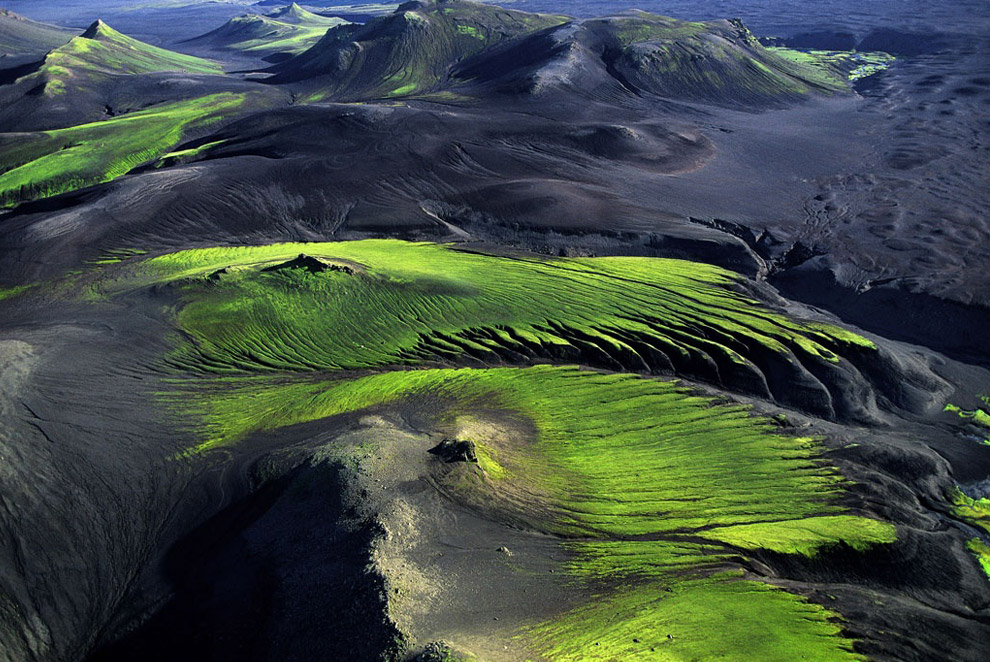
Mountainous countryside near Maelifellssandur, Myrdalsjökull Region, Iceland. Once the young lava fields of Iceland cool down, life begins anew little by little. Ice, wind and water flatten and carve out shapes to begin with, then, during the summer, bacteria, lichen and fungi prepare the soil for plants, in particular mosses which adapt to an environment which remains difficult. These plants colonise the most favourable sites and terrain little by little, forming a new ecosystem.
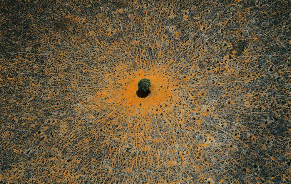
"Tree of life", Tsavo national park, Kenya. This acacia is a symbol of life in the vast expanses of thorny savanna, where wild animals come to take advantage of its leaves or its shade. Tsavo National Park in southeastern Kenya, crossed by the Nairobi-Mombasa road and railway axis, is the country's largest protected area (8,200 square miles, or 21,000 square kilometers) and was declared a national park in 1948.
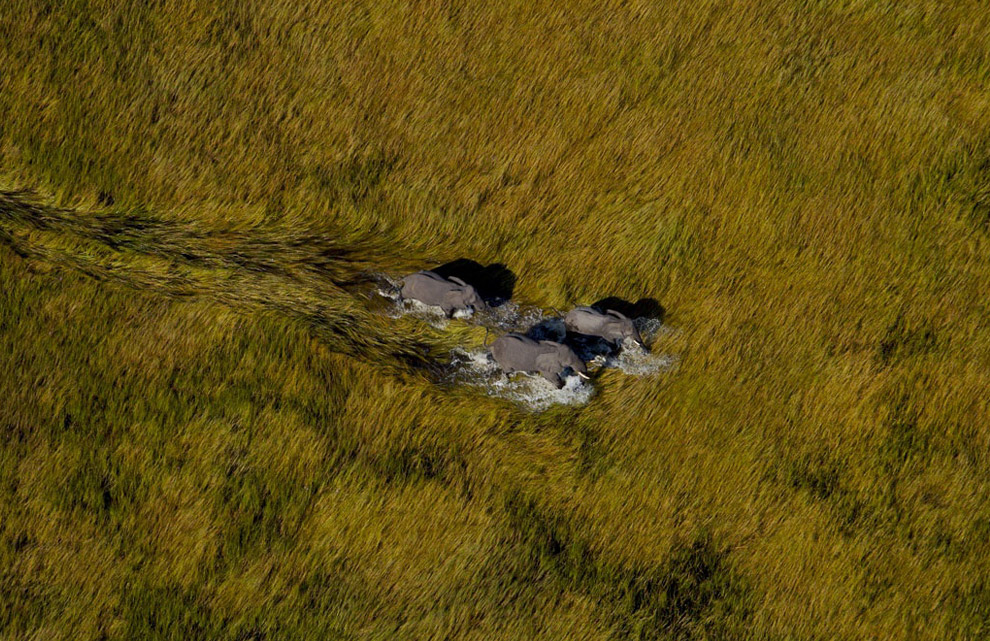
Elephants in the Okavango Delta, Botswana. The Okavango Delta is the world's largest inland delta, flooding seasonally, and is populated by five ethnic groups of people, sharing it with hundreds of species of animals.
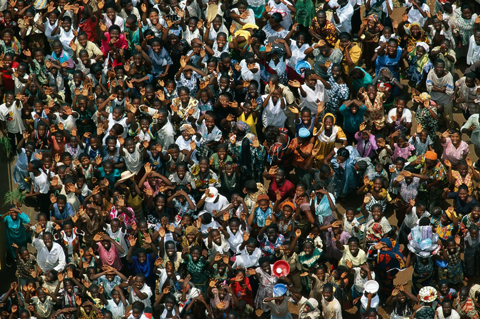
Crowd in Abengourou, Ivory Coast. Africa has a population of 800 million, making up 13 percent of the human race. This colorful crowd, enthusiastically waving to the photographer, was photographed in Abengourou, in eastern Ivory Coast.
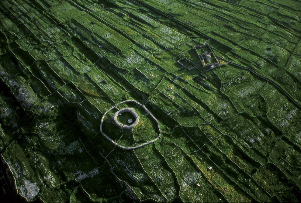
Dun Eochla fort on Inishmore Island, County Galway, Ireland. The fort of Dun Eochla, rising above the close-cropped grass, was built centuries ago on this island some 30 miles off the Irish coast. The Aran Islands contain some of Europe's most magnificent prehistoric remains. This trio of islands - Inishmore, Inishmaan, and Inisheer - with their high rocky cliffs protect the Galway coast from the violent winds and currents of the Atlantic. For centuries, their inhabitants have helped keep the soil fertile by regularly spreading a mixture of sand and seaweed on the rock to produce the thin layer of humus needed for farming. To protect their plots from wind erosion, the islanders have built a vast network of almost 7,500 miles (12,000 km) of low walls, which give the land the appearance of a vast mosaic.
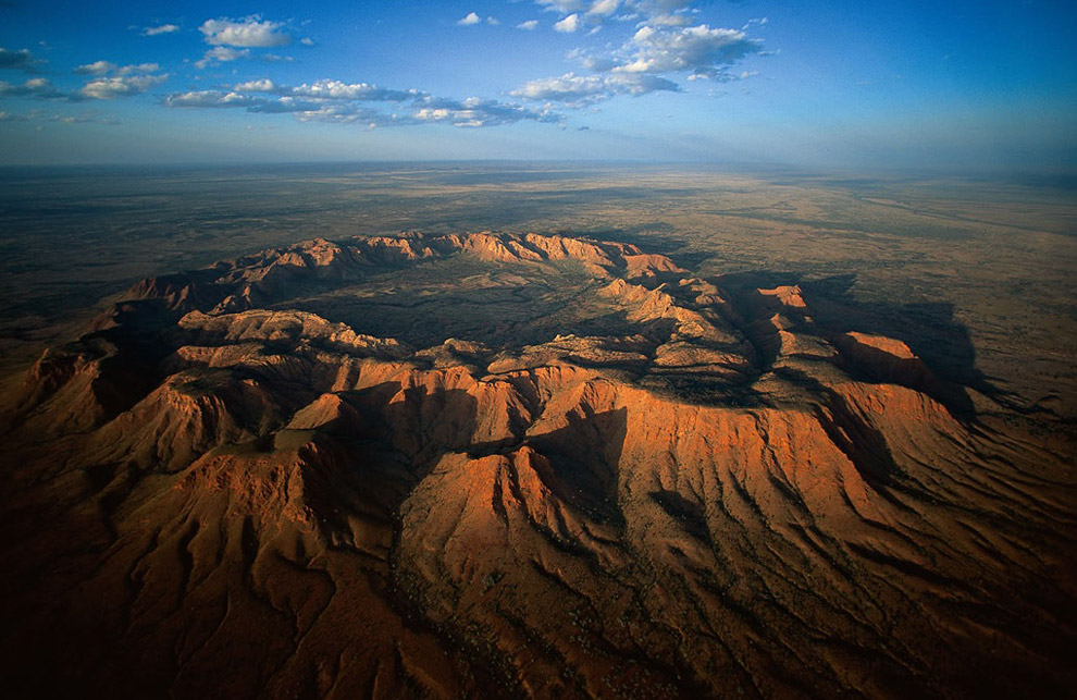
Gosse's Bluff meteor crater, Northern territory, Australia. Approximately 135 million years ago a meteorite fell on Australian soil, devastating more than 8 square miles (20 km2) in what is now the Northern Territory. Today a crater 3 miles (5 km) in diameter and 500 feet (150 m) deep remains, called Gosse's Bluff; it is known as Tnorala to the Aboriginal people.
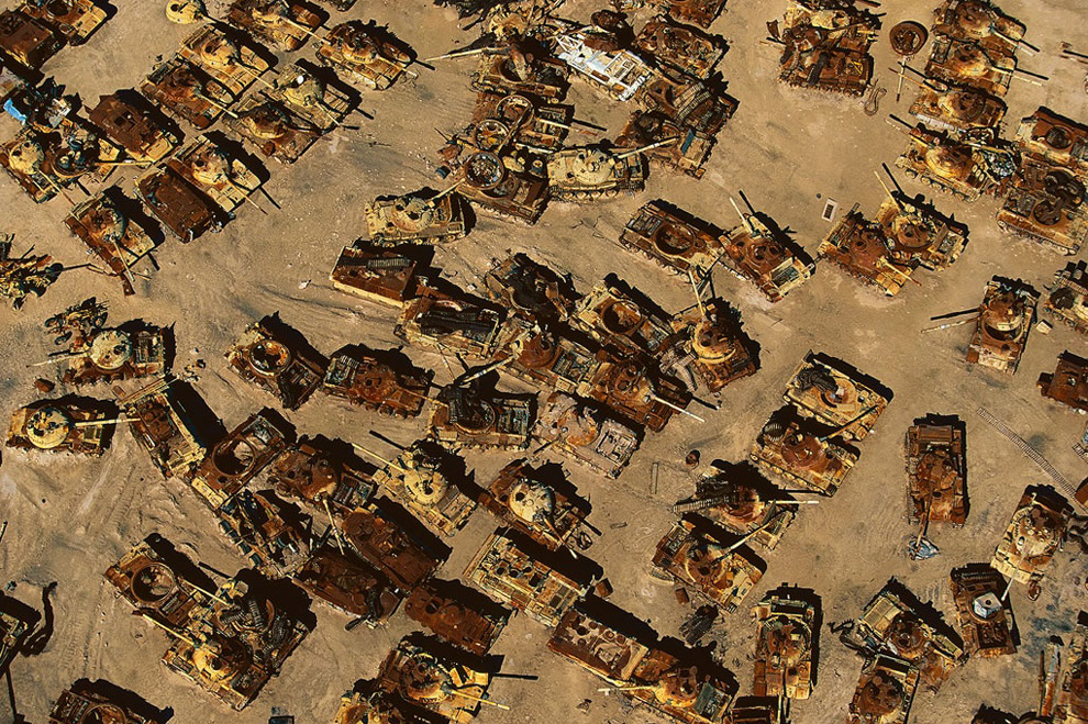
Iraqi tank graveyard in the desert near Al Jahrah, Kuwait. This graveyard of tanks will bear witness for many years to the damage that war causes both to the environment and to human health. In 1991, during the first Gulf War, a million depleted uranium shells were fired at Iraqi forces, spreading toxic, radioactive dust for miles around. Such dust is known to have lasting effects on the environment and to cause various forms of cancer and other serious illnesses among humans.
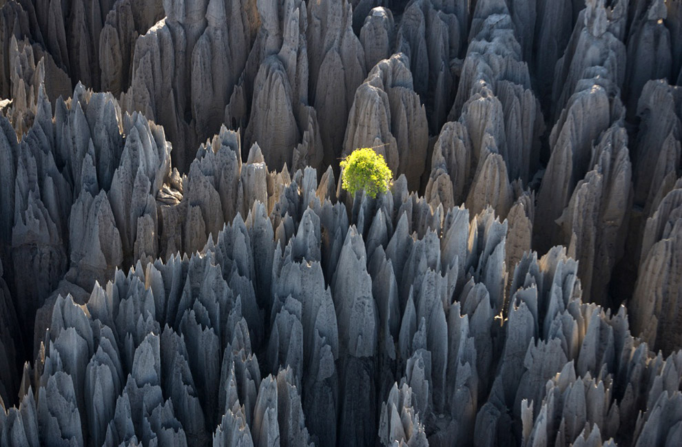
Tsingy of Bemaraha, Morondava region, Madagascar. A Nature reserve covering 853 square kilometers, it was established as a UNESCO World Heritage site in 1990.
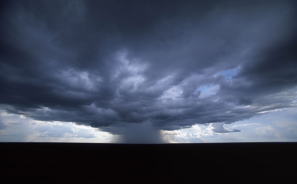
Storm over the Amazon rainforest, Amazonas State, Brazil. There are 50,000 storms a day on the planet, the Amazon river basin hosting many of those, receiving up to 80 inches of rain every year.
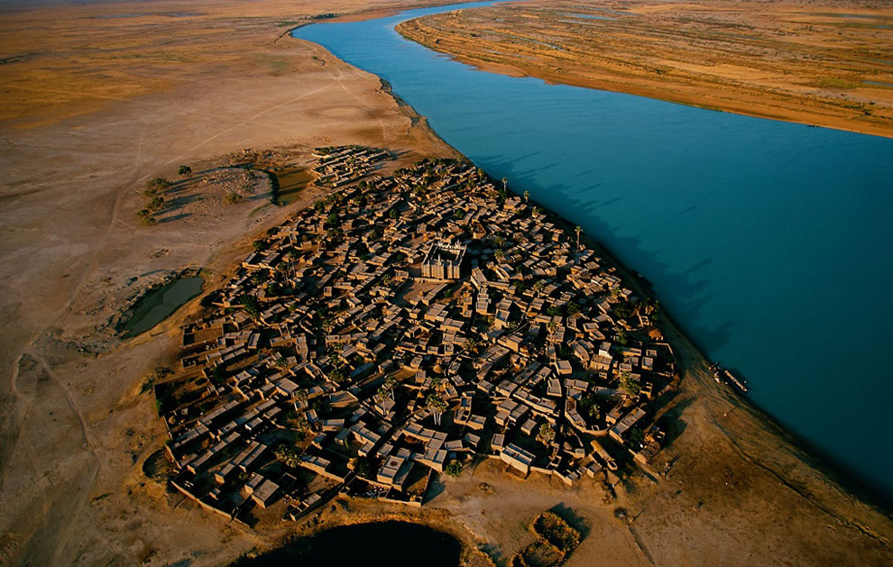
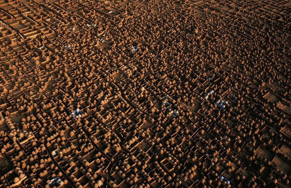
Village on the banks of an arm of the River Niger, Mopti region, Mali. The River Niger, which is the third-longest in Africa (2,600 miles, or 4,200 km), has its source in the heights of the Fouta Djalon in Guinea. It crosses nine countries until it reaches a vast delta in Nigeria, where it flows into the Atlantic Ocean. More than 100 million people live on its banks, trading on the river, fishing, raising cattle, and farming to the rhythm of the rise and fall of the waters between August and January.
Village in the Rheris Valley, Er Rachidia region, High Atlas Mountains, Morocco. Fortified villages are frequently seen along the valley of the Rheris, as they are on most rivers of southern Morocco, inspired by the Berber architecture built to protect against invaders. Today, with the threat of raids now gone, the close clustering of dwellings, small windows, and roofs covering houses and narrow streets serve the purpose of protecting occupants from heat and dust. The flat, connecting roofs also provide a place for drying crops.
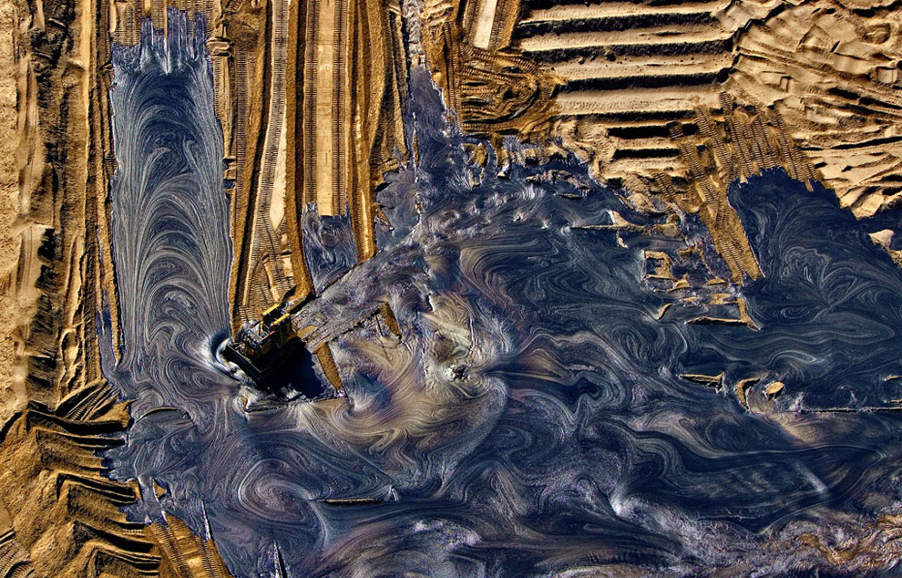
The Athabasca Oil Sands, Alberta, Canada. These oil deposits make up the largest reservoir of crude bitumen in the world, and as recently as 2006, produced over 1 million barrels of crude oil per day.
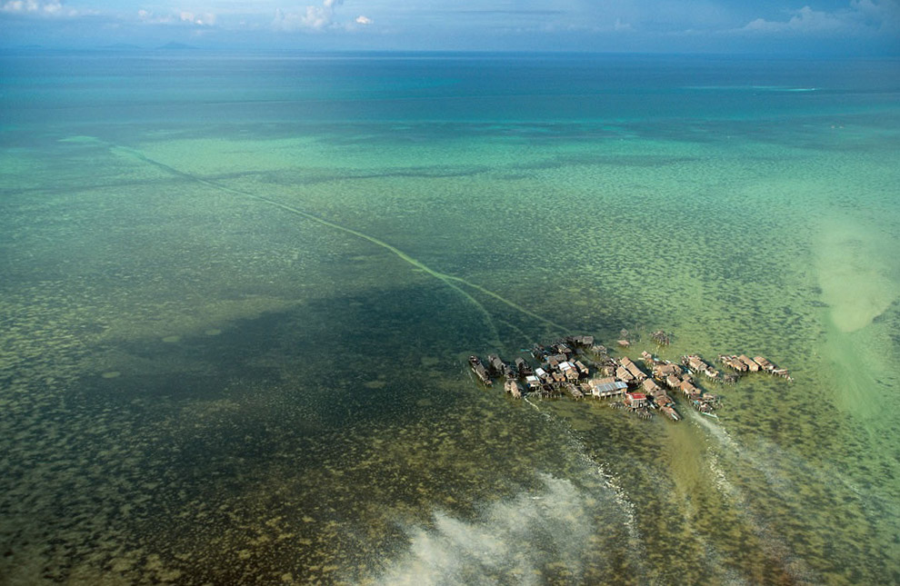
Village on stilts in Tongkil, Samales Islands, Philippines. The southern Philippines, and in particular the Sulu Archipelago that includes the Samales Islands, is home to the Badjaos. The Badjaos belong to a Muslim minority who make up 5 percent of the Philippine population and are concentrated mostly in the south of the country. Known as "sea gypsies", they fish and harvest shellfish and pearl oysters, and they live in villages on stilts. A channel carved out of the coral reef allows them to reach the open sea.
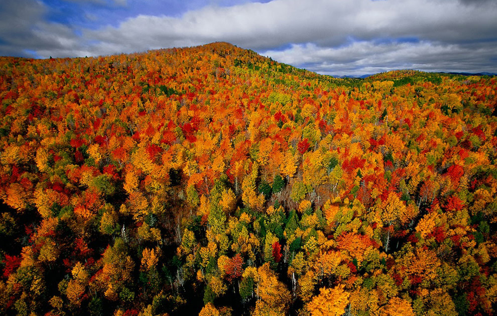
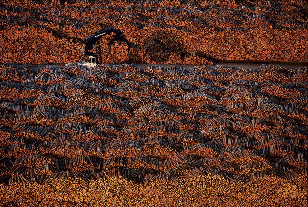
Autumn forest in the region of Charlevoix, Quebec, Canada. The hills of the Charlevoix region along the Saint Lawrence River in Quebec province are dominated by a mixed forest of deciduous trees and conifers. In 1988 UNESCO declared 1,800 square miles (4,600 km2) of this region a Biosphere Reserve. The Quebec forest, boreal in the north and temperate in the south, covers nearly two thirds of the province and has been exploited for lumber since the end of the 17th century. Today it contributes to the economic prosperity of Canada in the worldwide production of newsprint paper, paper pulp, and timber, as well as Christmas trees and maple syrup.
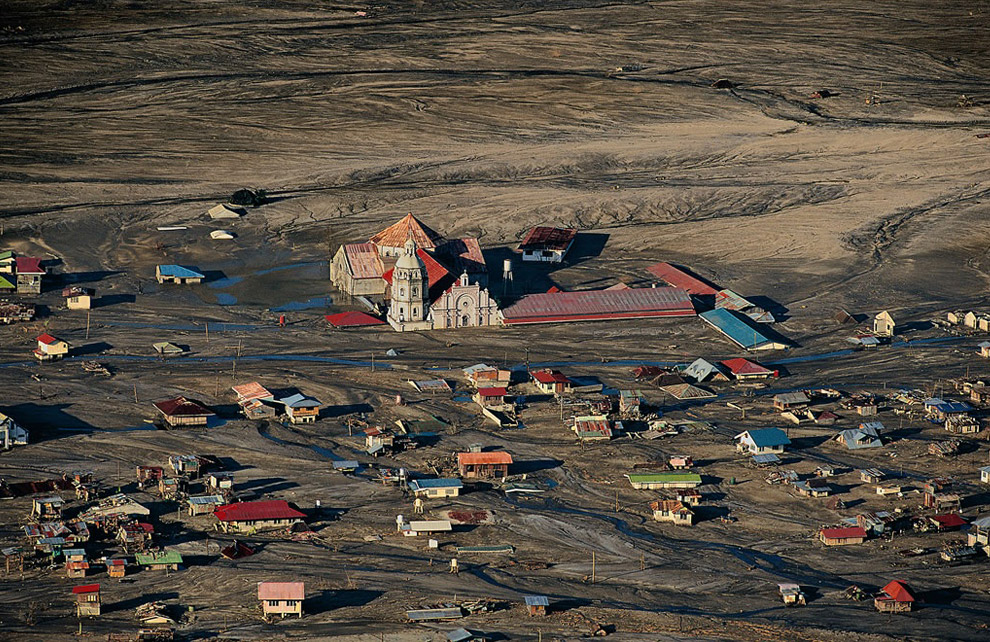
Village of Bacolor under a layer of mud, the island of Luzon, Philippines. In 1991 the volcano of Pinatubo, on the island of Luzon in the Philippines, began to erupt after nearly six centuries of dormancy, projecting a 66-million-cubic-foot (18-million-cubic-meter) cloud of sulfurous gas and ash to a height of 115,000 feet (35,000 m) and destroying all life within a radius of 9 miles (14 km). In the days that followed, torrential rains from a hurricane mixed with ashes scattered over several thousand kilometers, causing devastating mudflows, which engulfed whole villages. Before the cataclysmic eruption on June 15, 1991, the evacuation of 60,000 people limited casualties to 875 dead and 1 million injured.
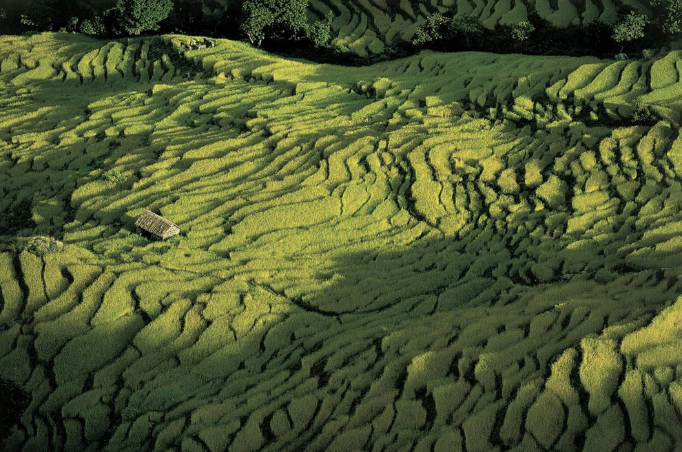
Rice field north of Pokhara, Nepal. The Himalayan mountain chain runs north of Nepal, separating it from its giant neighbor, China. The mountains crown Nepal with a string of eight peaks - out of a world total of fourteen - higher than 26,232 feet (8,000 m). The economy is based on agriculture, which employs 80 percent of the working population and accounts for 41 percent of the gross domestic product of one of the world's poorest countries. Generations of farmers have tamed the mountainsides and prevented erosion by cutting terraces. Rice paddies thus rise in tiers as high as 9,800 feet (3,000 m) above sea level, covering 45 percent of Nepal's cultivated land.
Stacks of wood at a wood pulp factory near Mörrum, Blekinge province, Sweden. The nine countries around the Baltic Sea have made efforts to reduce its pollution over the last 30 years. However, the state of this almost landlocked sea, tenuously linked to the North Sea by the Skagerrak and Kattegat straits, is still causing concern. A variety of chemicals - from wastewater, atmospheric pollution, and agricultural and industrial effluent - are building up in it.
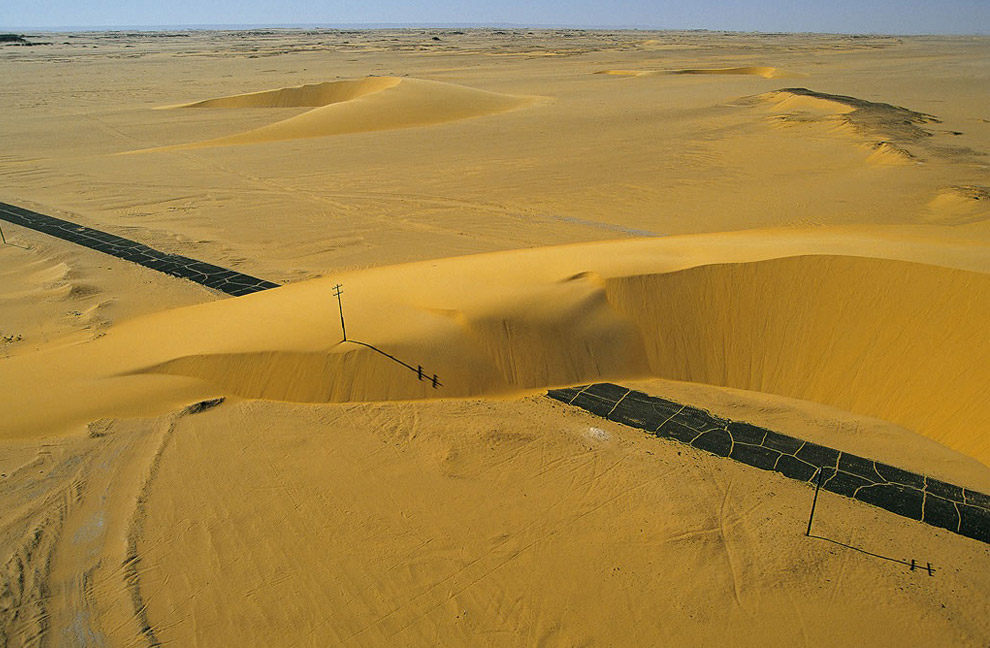
Road interrupted by a sand dune, Nile Valley, Egypt. Dunes cover nearly one-third of the Sahara, and the highest, in linear form, can attain a height of almost 1,000 feet (300 m). Barchans are mobile, crescent-shaped dunes that move in the direction of the prevailing wind at rates as high as 33 feet (10 m) per year, sometimes even covering infrastructures such as this road in the Nile Valley.
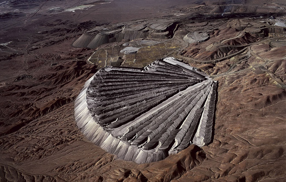
Waste from the copper mine at Chuquicamata, Chile. This giant scallop shell is made of earth. A crane deposits the earth in successive, slightly curved lines giving the appearance of sheets of sand lined up side by side. This earth is extracted with the copper, but it is separated from the ore by sieving. The metal is refined in the Chuquicamata foundry that, thanks to newly installed equipment, can now filter out 95 percent of the sulfur dioxide (SO 2 ) and 97 percent of the arsenic that the process releases.
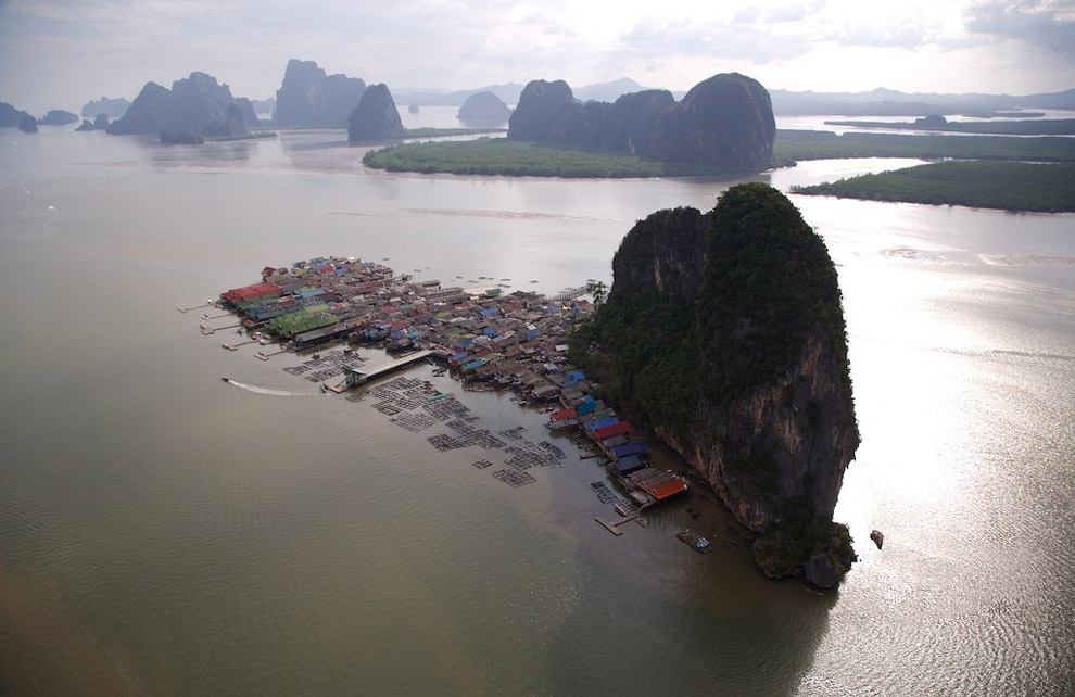
Town of Koh Pannyi, Phand Nga bay, Thailand. The south-western coast of Thailand offers a series of beautiful bays lined with many islands. Phang-nga Bay's special formations were created after the thawing of ice 15,000 years ago. Rising waters then submerged arid calcareous mountains, leaving only their peaks visible to the eye. The bay was turned into a marine park in 1981. One of its popular attractions is the village of Koh Panyi, which was built on piles two centuries ago by Muslim sailors coming from Malaysia. The inhabitants make a living via traditional fishing and tourism. Preserved by its configuration, the bay floor of Phang-nga Bay suffered much less from the tsunami of December 26, 2004 than nearby sites.
Modern graves in a cemetery at Asyut, Nile valley, Egypt. The idea of eternal life, so dear to the ancient Egyptians, is conveyed through a style of funerary architecture that stands the test of time. These tombs are divided into two sections, one representing the life of the deceased and the other containing the person's remains and the objects customarily regarded as making life in the hereafter more pleasant. The world of the living coexists with that of the dead, and cemeteries are close to towns. An Egyptian city of the dead can stretch over several miles and is laid out like a town, with a rich variety of open spaces and architecture.
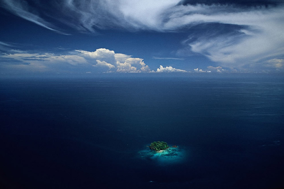
Islet in the Sulu Archipelago, Philippines. More than 6,000 of the 7,100 Philippine Islands are uninhabited, like this islet in the Sulu Archipelago, a set of 500 islands that separate the Celebes and the Sulu seas. Their extraordinary biodiversity is under threat, not from distant industrial sites but from the effects of global pollution. These islands, which barely rise above the surface of the water, are among the first potential victims of global warming and are certain to disappear when the sea level rises.
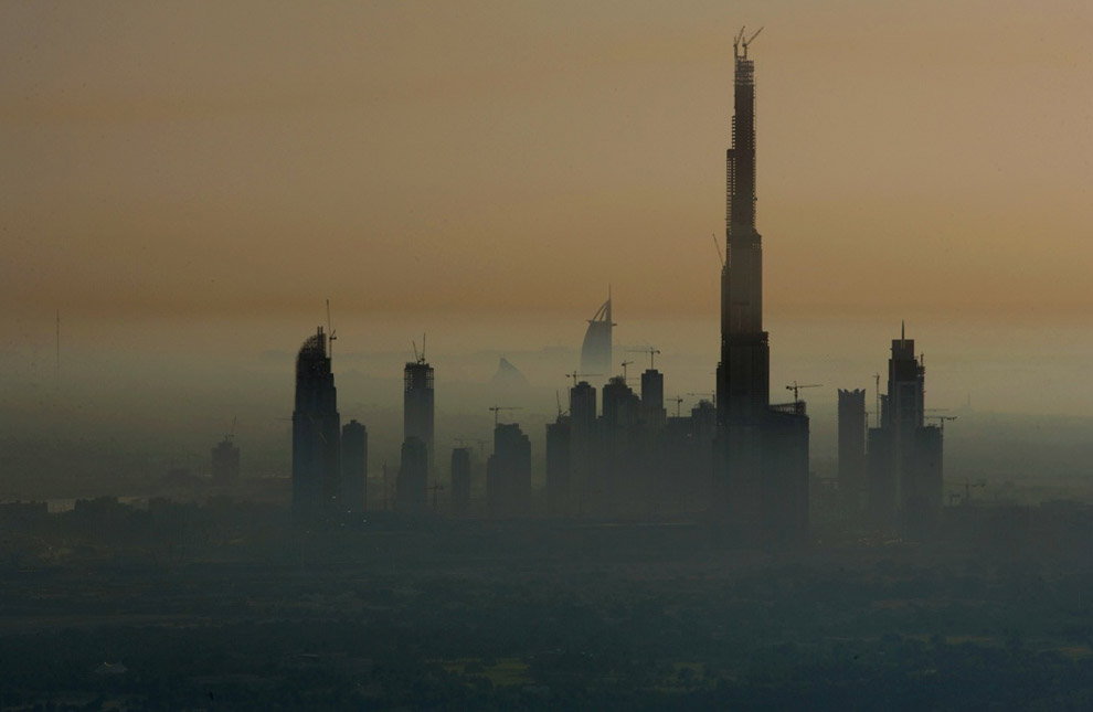
The Burj Dubai tower, under construction, will soon be the world's tallest structure, seen in Dubai, United Arab Emirates.
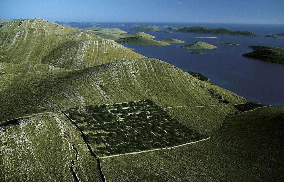
Island of Kornat, Kornati national park, Dalmatia, Croatia. The eastern edge of the Adriatic washes the shores of the 150 islands and islets that make up the Kornati archipelago. The largest island, Kornati, is 12.5 square miles (32.5 km2) in area and accounts for two-thirds of the archipelago's land surface. A century ago, the inhabitants of the nearby islands used these rocks to build dry-stone walls to pen in their sheep and keep them from their olive groves and vineyards. Overgrazing has done considerable damage to wildlife and to the thin vegetation.
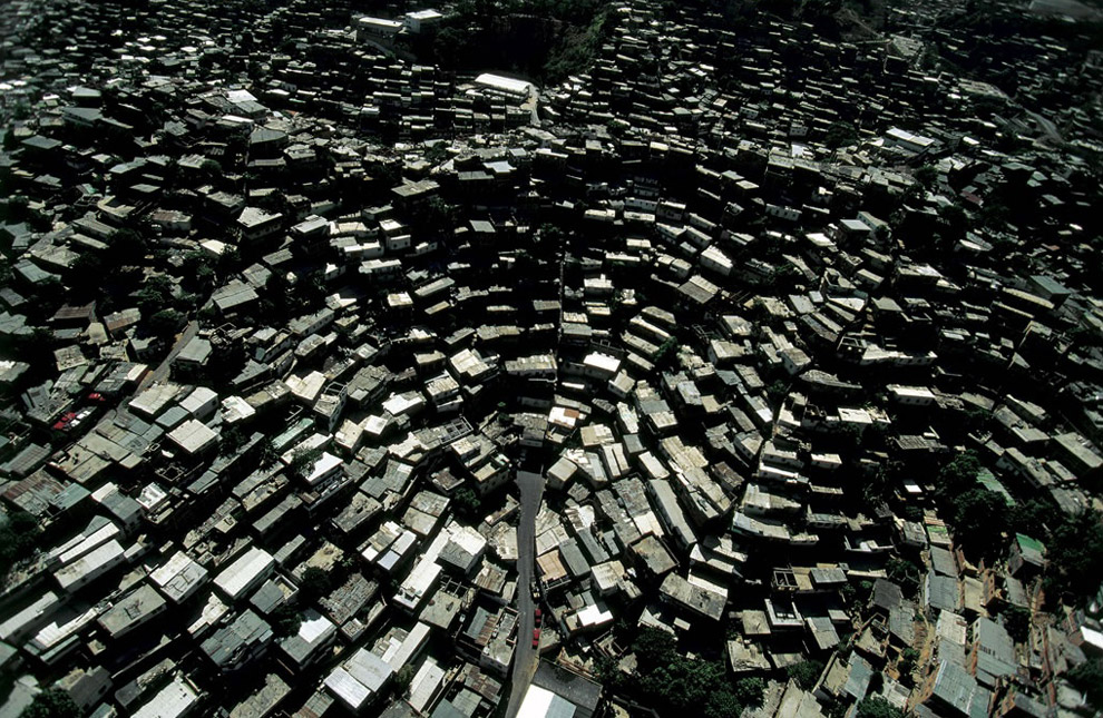
Barrios, Caracas, Venezuela. Caracas has grown enormously in the last 40 years, attracting people from all over South America, filling its narrow valley and climbing up the steep sides of the surrounding hills. These new districts, known as barrios or ranchos are home to more than 50 percent of Caracas's 3.8 million inhabitants.
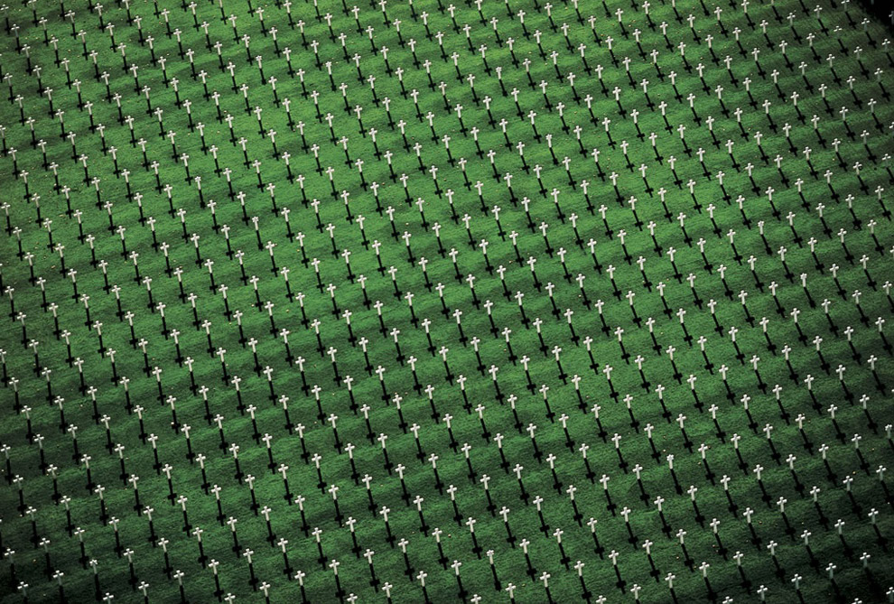
American cemetery north of Verdun, Meuse, France. Covering some 40 hectares (100 acres) at Romagne-sous-Montfaucon, 40 kilometers (25 miles) from Verdun, the American cemetery was dedicated in 1935 by the American Battle Monuments Commission. The commission was created in 1923 at the request of General Pershing, who had taken part in the American offensive of 1918. Its aim was to undertake architectural and landscape studies in order to restructure American cemeteries and commemorative monuments in Europe. Whereas the French army chose to build permanent cemeteries where temporary cemeteries had been made during the hostilities, the American army opted to create a single cemetery. Some 25,000 American tombs scattered around Verdun were then brought together at Romagne where, after almost half the bodies were repatriated to American soil, 14,246 soldiers have lain ever since.
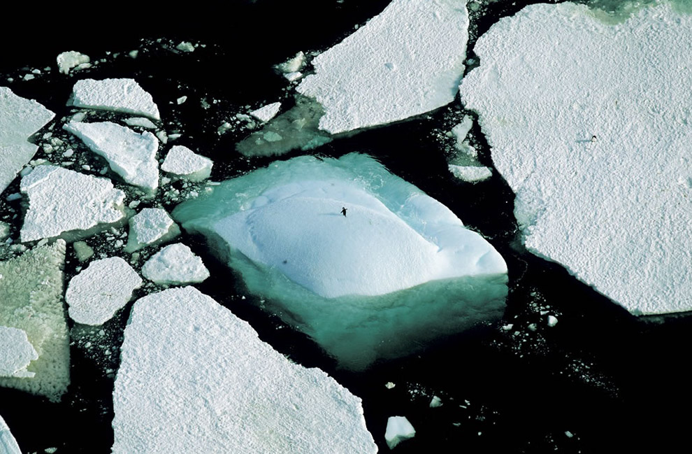
Icebergs and an Adelie penguin, Adelie Land, Antarctica. Antarctica, the sixth continent, is a unique observation point for atmospheric and climatic phenomena; its ancient ice, which trapped air when it was formed, contains evidence of the Earth's climate as it has changed and developed over the past millions of years.
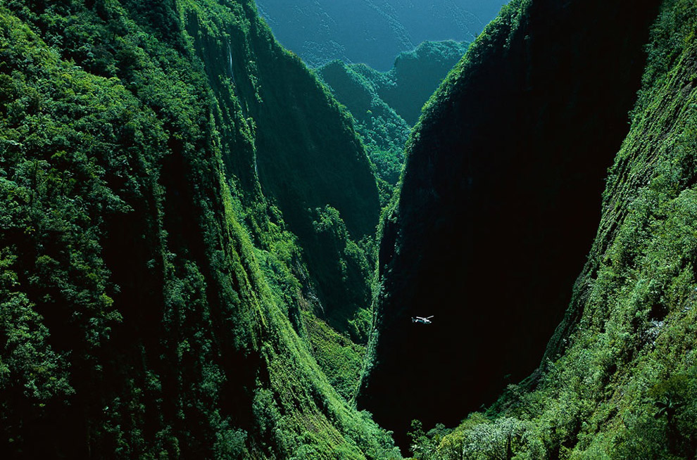
The Gorges of the Bras de Caverne, island of Reunion, France. Gorges created from volcanic fractures, like the bed of the Bras de Caverne river, make access to the center of the island of Réunion difficult. Some sites were explored only recently, such as the "Trou de Fer", a ravine of 820 feet (250 m) that was discovered in 1989. Because the island's center was protected from human encroachment, its tropical forests, with giant heather, ferns, and lichens, have been preserved, whereas the forests at low altitude have been converted to agricultural or urban use and have disappeared.
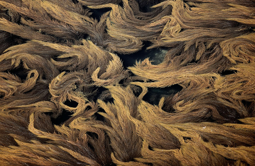
Algae in the Gulf of Morbihan, France. For more than a century, oyster farms have been the privileged sites for the introduction of exotic species. In the 1920s an epidemic decimated Crassostrea angulata, the most widely exploited oyster species in France. A Japanese species, Crassostrea gigas, was then introduced - and, involuntarily along with it, some thirty species of animals and algae that today live in the waters of the English Channel and the Atlantic Ocean. One example is the Sargasso (Sargassum muticum), a brown algae, seen here in the Gulf of Morbihan, where it has become a part of the local flora.
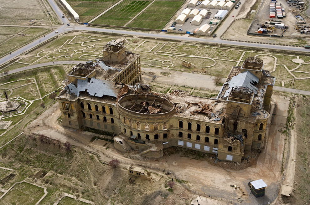
Darul Aman Palace, in Kabul, Afghanistan. First built in the 1920s by King Amanullah Khan, the palace has been destroyed (by fire and warfare) and rebuilt many times. Its re-reconstruction is in the planning and fundraising stage right now.
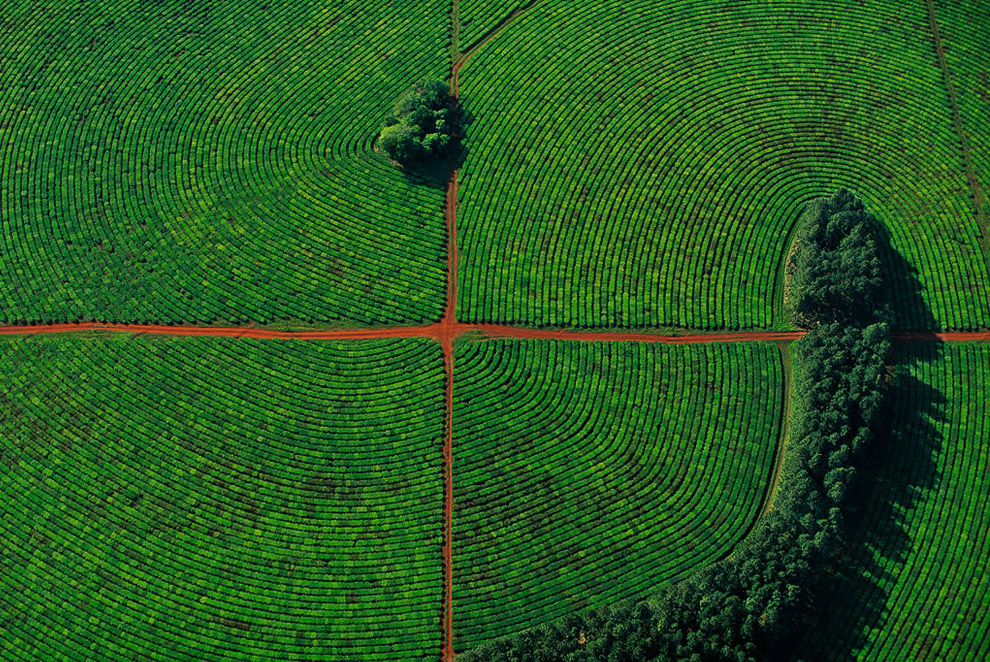
Tea cultivation in Corrientes province, Argentina. The fertility of the red soil and the regular rains of the Corrientes region create the ideal conditions for the cultivation of tea. In an effort to protect the soil against erosion, tea is planted along curved terraces and protected from the wind by hedges. Unlike Asian and African countries, where the young sprouts are handpicked, in Argentina mechanical harvesting is the rule, done mainly with high-clearance tractors that are driven along the straight rows of tea bushes.
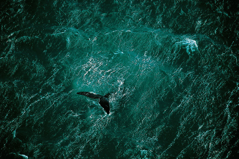
A whale swims off the Valdes peninsula, Argentina. After summering in the Arctic, whales return to the southern seas each winter to reproduce. From July to November, whales mate and bear their young along the coasts of the Valdes Peninsula in Argentina. Until the 1950s, this migratory marine mammal was extensively hunted for its meat and the oil extracted from its fat, which brought it to the edge of extinction. Protective measures were adopted after international attention was focused on the problem in 1937. In 1982 a moratorium was declared on whale hunting for commercial purposes, and in 1994 the southern seas became a whale sanctuary. After decades of protection, 7 of the 13 whale species, of which only a few thousand remain (10 to 60 times fewer than in the early 20th century), are still endangered.