-
Hey, guest user. Hope you're enjoying NeoGAF! Have you considered registering for an account? Come join us and add your take to the daily discourse.
You are using an out of date browser. It may not display this or other websites correctly.
You should upgrade or use an alternative browser.
You should upgrade or use an alternative browser.
Hurricane Season 2010: Getting a jump on June 1st
- Thread starter Xeke
- Start date
- Status
- Not open for further replies.
Relix said:
Taken from WU Poster Levy (awesome forecaster too =P) As you can see it's currently well right of the forecast points.
So what would you say the likelihood of it hitting near the Texas Louisiana border is?
jamesinclair
Banned
Emenis said:He noticed the oil spill and thought he would go fuck things up.

He? I thought alex was a she.
jamesinclair said:He? I thought alex was a she.
Nope, the list alternates between male and female names.
2010
------
Alex
Bonnie
Colin
Danielle
Earl
Fiona
Gaston
Hermine
Igor
Julia
Karl
Lisa
Matthew
Nicole
Otto
Paula
Richard
Shary
Tomas
Virginie
Walter
jamesinclair said:He? I thought alex was a she.
Alexander - Alex
perfectchaos007
Member
Agentnibs said:Looks like it's pointed towards me now. Lol. Most People here don't even know about the storm yet haha
thats because like you said, Corpus Christi is protected from hurricanes. why should they worry?
Insane Metal
Gold Member
Oh boy. This is looking bad.
Hurricane Warning issued for Mexico and South Texas.
000
WTNT41 KNHC 290248
TCDAT1
TROPICAL STORM ALEX DISCUSSION NUMBER 14
NWS TPC/NATIONAL HURRICANE CENTER MIAMI FL AL012010
1000 PM CDT MON JUN 28 2010
ALTHOUGH THE SATELLITE PRESENTATION OF ALEX CONTINUES TO BE A LITTLE
RAGGED-LOOKING...DATA FROM THE AIR FORCE HURRICANE HUNTERS INDICATE
THAT THE STORM IS GRADUALLY STRENGTHENING. PEAK 925 MB FLIGHT-LEVEL
WINDS WERE 68 KT AND MAXIMUM SFMR-MEASURED WINDS WERE 53 KT.
AIRCRAFT OBSERVATIONS ALSO SHOWED THAT THE MINIMUM CENTRAL PRESSURE
HAS DROPPED TO 985 MB...A RATHER LOW VALUE FOR A TROPICAL STORM.
BASED ON THE WIND MEASUREMENTS...THE INITIAL INTENSITY IS SET TO 55
KT FOR THIS ADVISORY.
CENTER FIXES FROM THE RECONNAISSANCE AIRCRAFT INDICATE THAT THE
STORM HAS DRIFTED MOSTLY NORTHWARD OVER THE PAST SEVERAL HOURS...AND
THE INITIAL MOTION ESTIMATE IS 360/4. THIS MOTION IS BELIEVED TO
BE TEMPORARY BECAUSE THE GLOBAL MODELS ARE FORECASTING A MID-LEVEL
RIDGE TO BUILD TO THE NORTH OF ALEX OVER THE NEXT COUPLE OF
DAYS...WHICH SHOULD INDUCE A GRADUAL BEND OF THE TRACK TO THE LEFT.
THE TRACK MODEL CONSENSUS HAS SHIFTED ABOUT A HALF DEGREE TO THE
NORTH DUE TO THE RECENT NORTHWARD MOTION...AND THE OFFICIAL
FORECAST IS ADJUSTED SLIGHTLY NORTHWARD AS WELL. ONE SHOULD NOT
FOCUS ON THE EXACT LANDFALL POINT...HOWEVER...SINCE THE AVERAGE
TRACK FORECAST ERROR IN THE 48- TO 72-HOUR TIME FRAME IS 100-150
NAUTICAL MILES.
THE WESTERLY SHEAR THAT WAS AFFECTING ALEX HAS ABATED AND THE SHIPS
MODEL DIAGNOSES A FURTHER DECREASE IN SHEAR...TO BELOW 10 KT IN 24
HOURS. AS ALEX MOVES AWAY FROM THE SHELF WATERS NEAR THE NORTHWEST
COAST OF THE YUCATAN...IT SHOULD PASS OVER WARMER SEA SURFACE
TEMPERATURES DURING THE NEXT 48 HOURS OR SO...ALTHOUGH THE
PROJECTED TRACK IS NOW A LITTLE TO THE NORTH OF A WARM EDDY OVER
THE SOUTHWEST GULF. IT IS STILL SOMEWHAT PUZZLING THAT THE GFDL
AND HWRF MODELS STILL DO NOT FORECAST ALEX TO BECOME A
HURRICANE...PARTICULARLY SINCE THE CYCLONE IS APPROACHING HURRICANE
STRENGTH AS WE SPEAK. THE OFFICIAL INTENSITY FORECAST IS CLOSE TO
THE STATISTICAL LGEM GUIDANCE...AND IS ESSENTIALLY THE SAME AS THE
PREVIOUS NHC FORECAST.
GIVEN THE LATEST 36-HR FORECAST POINT AND THE EXTENT OF
TROPICAL-STORM FORCE WINDS IN THE FORECAST...IT IS TIME TO UPGRADE
THE HURRICANE WATCH FOR TO A HURRICANE WARNING FOR THE SOUTH TEXAS
AND NORTHEAST MEXICAN COASTS.
FORECAST POSITIONS AND MAX WINDS
INITIAL 29/0300Z 21.0N 91.6W 55 KT
12HR VT 29/1200Z 22.2N 92.3W 65 KT
24HR VT 30/0000Z 23.6N 93.5W 70 KT
36HR VT 30/1200Z 24.5N 95.2W 75 KT
48HR VT 01/0000Z 25.2N 96.9W 80 KT
72HR VT 02/0000Z 25.7N 99.6W 45 KT...INLAND
96HR VT 03/0000Z 27.0N 102.0W 20 KT...INLAND
120HR VT 04/0000Z...DISSIPATED
Baraka in the White House
2-Terms of Kombat
They sound even more uncertain than usual about this one...
DOO13ER said:They sound even more uncertain than usual about this one...
Alex isn't behaving as they are predicting from what I can see.
Agentnibs said:Looks like it's pointed towards me now. Lol. Most People here don't even know about the storm yet haha
That just gives you an opportunity to go out and buy supplies now before everyone starts buying them and prices go up.
Smiles and Cries
Member
a warning? not a Watch?
Smiles and Cries
Member
how soon does the waves start pushing oil to the shores?
B.K. said:That just gives you an opportunity to go out and buy supplies now before everyone starts buying them and prices go up.
the local media will go into full on panic mode tomorrow morning so it's probably to late for that. I'm gonna try and get some stuff tomorrow since I have the day off.
People here are used to these projections though, we tend to have a storm pointing to us every season only for it to turn north last second. Hopefully thats the case this year.
As for oil I don't believe it'll be pushing much oil towards here if it stays on course. The texas coast has been unaffected by the oil, I think the oil is to far north for it splash here. Don't know about Louisiana though :/
Smiles and Cries
Member
where are the Weathermen this morning? Hello?
perfectchaos007
Member
Models shifted back south of Texas now. It's funny how often this system has changed paths.
Baraka in the White House
2-Terms of Kombat
Looks like they're expecting it to take a more westerly jog any minute now, wonder why?
DOO13ER said:Looks like they're expecting it to take a more westerly jog any minute now, wonder why?
They are expecting a ridge to build in the west and push it WNW. Still hasn't happened though it did take a WNW, moving back NW. I am still sticking with the close call of Mexico Norhtern border and then south Texas, or just plain a straight hit there.
11AM NHC:
"RAWINSONDE DATA THIS MORNING SHOW HEIGHT RISES FROM
850-500 MB OVER LOUISIANA AND TEXAS...INDICATING THE LOW/MID-LEVEL
RIDGE IN THIS AREA IS STRENGTHENING AS FORECAST BY THE LARGE-SCALE
MODELS. THE TRACK GUIDANCE IS IN GOOD AGREEMENT THAT ALEX WILL
GRADUALLY TURN WEST-NORTHWESTWARD AND WESTWARD ON THE SOUTH SIDE OF
THIS RIDGE AS IT STRENGTHENS FURTHER DURING THE NEXT 24-48 HR.
INDEED...THE ECMWF AND THE NAM SUGGEST ALEX COULD TURN SOUTH OF
WEST AFTER IT MAKES LANDFALL. THE NEW FORECAST TRACK IS SHIFTED A
LITTLE TO THE SOUTH AND IS FASTER THAN THE PREVIOUS TRACK BASED ON
CURRENT POSITION AND MOTION."
Baraka in the White House
2-Terms of Kombat
Looks like we'll see some rainbands along the upper Texas coast. This thing's size reminds me of Ike.
What city do you live in?MAB128 said:Damn, I haven't done much to get prepared.
City's practically in panic mode getting supplies and stuff.
It surprises me every time. We may be laid back around these parts, but if we hear the word "hurricane" the majority of us run to get supplies.
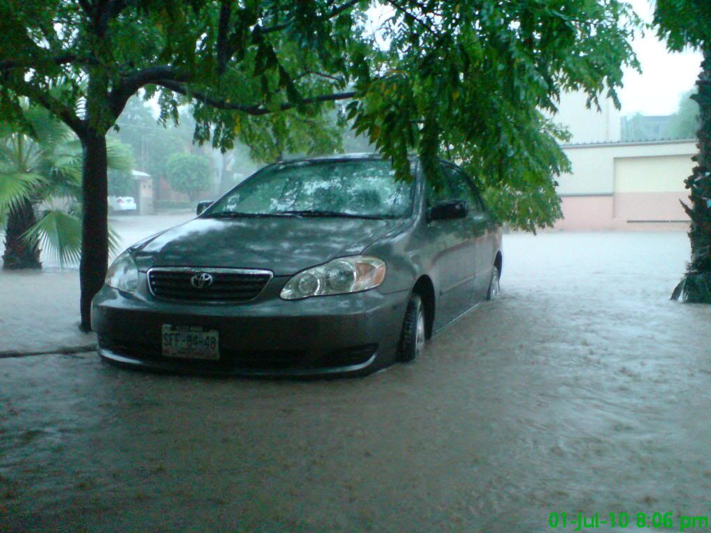
The situation is getting bad here in Monterrey, NL., Mex, here are some videos of the water on Santa Catarina river.
http://www.youtube.com/watch?v=YSxcKEat73k
http://www.youtube.com/watch?v=8Yrwt770FhU


The thing is, that was a few hours ago, I'm watching the news and things got worse, water is already on many streets, a few people are trapped in their cars and a lot of roads are closed.
We hadn't seen the "river" so full since hurricane Gilbert.
http://www.youtube.com/watch?v=YSxcKEat73k
http://www.youtube.com/watch?v=8Yrwt770FhU
The thing is, that was a few hours ago, I'm watching the news and things got worse, water is already on many streets, a few people are trapped in their cars and a lot of roads are closed.
We hadn't seen the "river" so full since hurricane Gilbert.
GaussTek said:The situation is getting bad here in Monterrey, NL., Mex, here are some videos of the water on Santa Catarina river.
http://www.youtube.com/watch?v=YSxcKEat73k
http://www.youtube.com/watch?v=8Yrwt770FhU
The thing is, that was a few hours ago, I'm watching the news and things got worse, water is already on many streets, a few people are trapped in their cars and a lot of roads are closed.
We hadn't seen the "river" so full since hurricane Gilbert.
That's a lot of water and probably more rain to come too. Take care down there man!
The worst is over.
Reports says there are six people dead, here in Nuevo León. Still, a few roads are closed and a lot of streets damaged. A lot of people were evacuated yesterday and there were few landslides.

^ Luckily there, people were evacuated on time (I think).
Cellphone services and fixed phone line have problems, including Internet (service just reestablished here a few hours ago, was off all night). No school/college and a lot of industries and shops are closed.
People are comparing the damage with Gilbert.
This is a photo taken outside my house yesterday. Water was so close to get inside. Nothing major happened here but damn, that was scary lol
Reports says there are six people dead, here in Nuevo León. Still, a few roads are closed and a lot of streets damaged. A lot of people were evacuated yesterday and there were few landslides.
^ Luckily there, people were evacuated on time (I think).
Cellphone services and fixed phone line have problems, including Internet (service just reestablished here a few hours ago, was off all night). No school/college and a lot of industries and shops are closed.
People are comparing the damage with Gilbert.
This is a photo taken outside my house yesterday. Water was so close to get inside. Nothing major happened here but damn, that was scary lol
A.Romero
Member
It hit some places pretty bad.
I'm in Nuevo Leon but we did OK in my area. Mostly.
The people comparing this to Gilbert are idiots.There is no point of comparisson other than both are metereological phenomena.
Monterrey is not built to handle these kind of situations. The city floods whenever someone spits on the street.
Also, the river is overflown and people actually go there with their families to take pictures of it. Its just retarded...
Anyway, I feel sorry for the people that died and the affected in general, but it has been way worse in the past.
Huevos de Oro
Member
Pretty rough stuff for my Monterrey fellows. Images and videos have been shocking.
perfectchaos007
Member
Damn, Alex did quite a number on Monterrey.
And to make matters worse, theres potential development of tropical activity near the oil spill region. And if it does form, it's forecasted to move west.

And to make matters worse, theres potential development of tropical activity near the oil spill region. And if it does form, it's forecasted to move west.
perfectchaos007 said:Damn, Alex did quite a number on Monterrey.
And to make matters worse, theres potential development of tropical activity near the oil spill region. And if it does form, it's forecasted to move west.
Just saw that.
It would form really close to land but still could dump a lot of rain just like Allison did in 2001.
perfectchaos007
Member
Emenis said:Just saw that.
It would form really close to land but still could dump a lot of rain just like Allison did in 2001.
:lol :lol like we need more rain. Angleton is in worse shape than LJ right now too
perfectchaos007
Member
Relix said:I don't think that will get to form. In fact I am looking more at the wave east of the Antilles and a cluster in central caribbean.
yeah apparently the Euro model already has that thing forming and hitting Mexico like Alex did :lol
Relix said:I don't think that will get to form. In fact I am looking more at the wave east of the Antilles and a cluster in central caribbean.
Do you have a good satellite shot of that? I was reading about it but I haven't been able to find a good image.
jamesinclair
Banned
GaussTek said:The situation is getting bad here in Monterrey, NL., Mex, here are some videos of the water on Santa Catarina river.
http://www.youtube.com/watch?v=YSxcKEat73k
http://www.youtube.com/watch?v=8Yrwt770FhU
Now that is a fucking river.
perfectchaos007
Member
Now the NHC has finally acknowledged the systym in the lower antilles. They give it a 10% chance of development right now.
The NHC always seems to be very conservative in their estimates.perfectchaos007 said:Now the NHC has finally acknowledged the systym in the lower antilles. They give it a 10% chance of development right now.
Baraka in the White House
2-Terms of Kombat
Someone's got it in for the Gulf, man. It's almost like the Earth knows...
DOO13ER said:Someone's got it in for the Gulf, man. It's almost like the Earth knows...
It's really only a matter of time till a monster crosses than oil spill, not if but when.
perfectchaos007
Member
30% chance of development now. It's looking more and more like Alex de ja vu
Almighty_Chocobo
Member
perfectchaos007 said:30% chance of development now. It's looking more and more like Alex de ja vu
Yeah was at either 10% or 20% (can't remember) when I looked earlier this morning. Just checked now and it's been upgraded to 30%.
Relix said:Wave in Central Caribbean looking really good with lots of convection. The one east of the Antilles is also looking hot.
It looks like Alex 2.0
- Status
- Not open for further replies.