• Hey, guest user. Hope you're enjoying NeoGAF! Have you considered registering for an account? Come join us and add your take to the daily discourse.

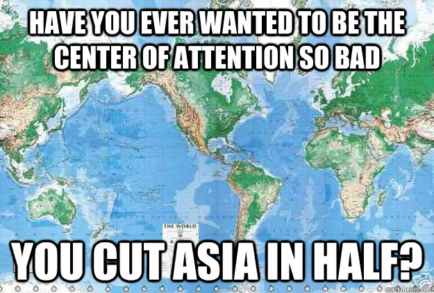
I never knew the world map was actually like this

Status
Not open for further replies.
So I was watching The West Wing on Netflix, when the episode "Somebody's Going to Emergency, Somebody's Going to Jail" comes up. During it, CJ interviews some guys who want the map used in schools changed to the Peters Projection, instead of the Mercator one used today.

(Top one is Mercator, bottom is the Peters Projection)
time_zones_4.jpg

Gall%E2%80%93Peters_projection_SW.jpg

I never knew the map I had been looking at all this time was wholly inaccurate when it came to the actual sizes of the continents and countries.
 

Metrotab

Banned
I remember something about the Mercator projection being very useful for sea navigation, and that's how it got popularised.
 

Christine

Member
I never knew the map I had been looking at all this time was wholly inaccurate when it came to the actual sizes of the continents and countries.

You never noticed the disparity between a flat map and a globe?

The mercator is no more or less accurate than any other projection per se, it's just that areas aren't comparable at different latitudes. Different projections have different limitations and uses.
 

thomaser

Member
Yep, it's striking to see just how big Africa is compared to the "western world". It's almost as big as the whole Eurasian continent!
 
D

Deleted member 1235

Unconfirmed Member
I knew this, but always sort of forget and then see it again and think 'fuck yeah, australia is MASSIVE' all over again.
 

TUSR

Banned
lol where?

Growing up in elementary school and middle school, the maps we had provided were printed by american companies which showed the USA being bigger than Canada. Physically.


Not sure if I can be any clearer.
 
The bottom map seems to take the curvature of the Earth into its design, which just makes some shit harder to see.

I don't see a problem with the Mercator map.
 

Kinitari

Black Canada Mafia
So I was watching The West Wing on Netflix, when the episode "Somebody's Going to Emergency, Somebody's Going to Jail" comes up. During it, CJ interviews some guys who want the map used in schools changed to the Peters Projection, instead of the Mercator one used today.


I never knew the map I had been looking at all this time was wholly inaccurate when it came to the actual sizes of the continents and countries.

Uhh, the Peters Projection seems less accurate for size. I think it considers the curvature of the earth better, but that's it.
 

Lamel

Banned
It really goes to show how we have certain learned constructs within our brains, and going even slightly against them is heavily noticeable.
 

Guevara

Member
So I was watching The West Wing on Netflix, when the episode "Somebody's Going to Emergency, Somebody's Going to Jail" comes up. During it, CJ interviews some guys who want the map used in schools changed to the Peters Projection, instead of the Mercator one used today.
I was just watching this scene too. I thought of it based on the thread title.
 

Metrotab

Banned
Can someone explain why the Mercator map has the property of exaggerating areas further from the equator?

All parallells are drawn equal on the Mercator map. This has the effect of stretching it when you get closer to the poles, where the parallells are shorter.
 

phisheep

NeoGAF's Chief Barrister
Uhh, the Peters Projection seems less accurate for size. I think it considers the curvature of the earth better, but that's it.

No. The Peters is accurate for relative areas of things, in the same way Mercator is accurate for constant bearings. Africa really is that big relative to everything else.
 

jred2k

Member
Maps are really only ever good at showing one characteristic well, especially on a scale as vast as the world. Try drawing something on to an orange and taking off the peel all as one piece. Then flatten out the peel and watch how much distortion you create.
 
Status
Not open for further replies.
Top Bottom