• Hey, guest user. Hope you're enjoying NeoGAF! Have you considered registering for an account? Come join us and add your take to the daily discourse.

2013 US Tornado Season

Status
Not open for further replies.

Seraphis Cain

bad gameplay lol
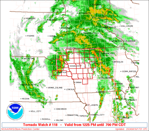
Figured I'd start this thread today since it's shaping up to be a potentially bad day for Oklahoma, Missouri, and north Texas. There's already a tornado watch in effect for most of Missouri.

From the SPC:

Fo0O5JO.png


From The Weather Channel's TOR:CON Index page:

Wednesday, April 17

Severe thunderstorm and tornado outbreak possible. Severe thunderstorms in west, central, and
northeast OK (excluding panhandle), extreme east TX panhandle and northwest TX near Abilene
and Wichita Falls, south-central and east KS, MO, IL, west and south IN, central KY,
east TN, extreme north GA, west NC, extreme northwest SC. Maximum TOR:CON - 7 south-central and
central OK; 5 southwest Missouri

Wednesday Night, April 17-18

Severe thunderstorms with a tornado threat early, becoming more of a line of storms moving
across OK and TX by morning. Severe thunderstorms in central TX, southwest, central, and east
OK, northwest AR, southeast KS, north, central, and southwest MO, central and south IL, south
half IN. Maximum TOR:CON - 6 south-central OK, 5 north-central TX; 4 central MO, central IL.

A multimedia briefing from the NWS/SPC can be found here.

And also from the NWS/SPC, the Public Severe Weather Outlook for today.

If you live in any of these areas, stay safe, GAF!
 

FelixOrion

Poet Centuriate
I've gotten so used to growing up in Tornado Alley that I don't even really care about tornadoes anymore, honestly.
 

Seraphis Cain

bad gameplay lol
Here's the info for the tornado watch currently in effect:

SEL4

URGENT - IMMEDIATE BROADCAST REQUESTED
TORNADO WATCH NUMBER 114
NWS STORM PREDICTION CENTER NORMAN OK
1110 AM CDT WED APR 17 2013

THE NWS STORM PREDICTION CENTER HAS ISSUED A

* TORNADO WATCH FOR PORTIONS OF
WEST CENTRAL ILLINOIS
EXTREME EASTERN KANSAS
WESTERN AND CENTRAL MISSOURI

* EFFECTIVE THIS WEDNESDAY MORNING THROUGH THIS EVENING FROM 1110 AM
UNTIL 1000 PM CDT.

* PRIMARY THREATS INCLUDE...
SEVERAL INTENSE TORNADOES POSSIBLE
SEVERAL LARGE HAIL EVENTS WITH A FEW VERY LARGE HAIL EVENTS TO
2.5 INCHES IN DIAMETER POSSIBLE
SEVERAL DAMAGING WIND GUSTS TO 70 MPH POSSIBLE

THE TORNADO WATCH AREA IS APPROXIMATELY ALONG AND 110 STATUTE
MILES EAST AND WEST OF A LINE FROM 65 MILES NORTH NORTHEAST OF
COLUMBIA MISSOURI TO 25 MILES SOUTH OF MONETT MISSOURI.
FOR A
COMPLETE DEPICTION OF THE WATCH SEE THE ASSOCIATED WATCH OUTLINE
UPDATE (WOUS64 KWNS WOU4).

PRECAUTIONARY/PREPAREDNESS ACTIONS...

REMEMBER...A TORNADO WATCH MEANS CONDITIONS ARE FAVORABLE FOR
TORNADOES AND SEVERE THUNDERSTORMS IN AND CLOSE TO THE WATCH
AREA. PERSONS IN THESE AREAS SHOULD BE ON THE LOOKOUT FOR
THREATENING WEATHER CONDITIONS AND LISTEN FOR LATER STATEMENTS
AND POSSIBLE WARNINGS.

&&

OTHER WATCH INFORMATION...CONTINUE...WW 113...

DISCUSSION...THUNDERSTORM DEVELOPMENT IS EXPECTED TO RAPIDLY
INCREASE IN COVERAGE THIS AFTERNOON...POSSIBLY INCLUDING AN EVOLVING
MESOSCALE CONVECTIVE SYSTEM...IN ADDITION TO DISCRETE SUPERCELLS.
THE ENVIRONMENT...PARTICULARLY ACROSS PARTS OF WESTERN INTO CENTRAL
MISSOURI MAY BECOME INCREASINGLY CONDUCIVE TO A STRONG TORNADO OR
TWO...IN ADDITION TO THE RISK FOR LARGE HAIL AND DAMAGING WIND
GUSTS.
 

FelixOrion

Poet Centuriate
When one comes down your street, will you start caring again?

naw, i'll be the basement chilling and all that.

i mean yeah they're dangerous and all that, of course, but I've been through my fair share of storms too; just kinda get used to it.
 

Credo

Member
My thoughts and prayers will be with everyone in the paths of the storms this year. Hopefully, there won't be another system like the 2011 Southeastern outbreak.

Is there anywhere in the U.S. that's free of tornadoes, earthquakes, and hurricanes?
 

Sub_Level

wants to fuck an Asian grill.
Damn, Kansas and Oklahoma might be more intense, but almost 100% of Missouri has a chance for tornados. You're still safe in west Kansas and the pan handle, but there's nowhere to go in Missouri.

And yeah, I wish the best for everyone there.
 

MotherFan

Member
Damn, Kansas and Oklahoma might be more intense, but almost 100% of Missouri has a chance for tornados. You're still safe in west Kansas and the pan handle, but there's nowhere to go in Missouri.

And yeah, I wish the best for everyone there.

Basement :p

In all honesty it is unlikely to be hit by a tornado, but most people who liver around here have had a close call. The storms today are not likely (imo) to produce alot of damaging tornadoes.
 

DietRob

i've been begging for over 5 years.
My thoughts and prayers will be with everyone in the paths of the storms this year. Hopefully, there won't be another system like the 2011 Southeastern outbreak.

Is there anywhere in the U.S. that's free of tornadoes, earthquakes, and hurricanes?

North Dakota?
 
I've been through my fair share of storms too; just kinda get used to it.
You're used to chilling in the basement and having some rain and wind. Shit like this is why we have warnings to begin with.

I was born and raised in Central Nebraska, I know all about Tornado complacency. Most people I know head outside to see if they can catch a glimpse or video tape it. A vast majority of the time there isn't anything to see, but all it takes is one time for something like what rolled through Tuscaloosa as few years ago to wipe your house or town off the map
 

Goro Majima

Kitty Genovese Member
As someone who lived in tornado alley for years and years, you develop a numbness to tornado seasons. Especially considering the odds of a tornado coming near your house is fairly slim. The odds of a hurricane hitting you on the coast for instance are probably a whole lot greater.

It's still scary and crazy for the people who are unlucky enough to be affected by them though.
 
I've visually seen three in my life here in KC.

Like others say, it's worth keeping your eyes (and a browser tab with a weather map) open, but after enough years, you just run out of concern.
 

FelixOrion

Poet Centuriate
You're used to chilling in the basement and having some rain and wind. Shit like this is why we have warnings to begin with.

I was born and raised in Central Nebraska, I know all about Tornado complacency. Most people I know head outside to see if they can catch a glimpse or video tape it. A vast majority of the time there isn't anything to see, but all it takes is one time for something like what rolled through Tuscaloosa as few years ago to wipe your house or town off the map

You're talking to another Nebraskan, btw. I remember when Hallam was wiped out too.
 
I think we had a hailstorm the past saturday in the lafayette, LA area. kinda wonder if there were any tornadoes that touched down then.
 
Shit is starting to get real in southwest Oklahoma (near Lawton)

EDIT: Tornado is on the ground southwest of Lawton, moving northeast toward city

EDIT 2: There are TWO supercells with rotation: one over Lawton and one southwest of Lawton moving toward the city. No tornado reported on the ground at this moment.
 
I find it interesting how tornadoes are incredibly rare outside North America.

Pretty much all tornadoes on earth occur in the U.S.

It is pretty weird, bet it has something to do with the geography and such but still, it is crazy that they usually hit here.

Once upon a time I was interested in storm chasing...still enjoy seeing thunderstorms and would love to see a tornado...just from an insanely safe distance.
 
SEL3

URGENT - IMMEDIATE BROADCAST REQUESTED
TORNADO WATCH NUMBER 123
NWS STORM PREDICTION CENTER NORMAN OK
935 AM EDT THU APR 18 2013

THE NWS STORM PREDICTION CENTER HAS ISSUED A

* TORNADO WATCH FOR PORTIONS OF
EASTERN ILLINOIS
CENTRAL AND EASTERN INDIANA
SOUTHERN LOWER MICHIGAN
NORTHWEST OHIO OHIO
LAKE MICHIGAN

* EFFECTIVE THIS THURSDAY MORNING AND AFTERNOON FROM 935 AM UNTIL
500 PM EDT.

...THIS IS A PARTICULARLY DANGEROUS SITUATION...

* PRIMARY THREATS INCLUDE...
SEVERAL INTENSE TORNADOES LIKELY
SEVERAL SIGNIFICANT DAMAGING WIND GUSTS TO 80 MPH POSSIBLE
A FEW VERY LARGE HAIL EVENTS TO 2 INCHES IN DIAMETER POSSIBLE

THE TORNADO WATCH AREA IS APPROXIMATELY ALONG AND 75 STATUTE
MILES EAST AND WEST OF A LINE FROM 65 MILES EAST NORTHEAST OF
SOUTH BEND INDIANA TO 60 MILES SOUTH SOUTHWEST OF TERRE HAUTE
INDIANA. FOR A COMPLETE DEPICTION OF THE WATCH SEE THE
ASSOCIATED WATCH OUTLINE UPDATE (WOUS64 KWNS WOU3).

PRECAUTIONARY/PREPAREDNESS ACTIONS...

REMEMBER...A TORNADO WATCH MEANS CONDITIONS ARE FAVORABLE FOR
TORNADOES AND SEVERE THUNDERSTORMS IN AND CLOSE TO THE WATCH
AREA. PERSONS IN THESE AREAS SHOULD BE ON THE LOOKOUT FOR
THREATENING WEATHER CONDITIONS AND LISTEN FOR LATER STATEMENTS
AND POSSIBLE WARNINGS.

&&

OTHER WATCH INFORMATION...CONTINUE...WW 122...

DISCUSSION...DISCRETE SUPERCELL DEVELOPMENT IS POSSIBLE AHEAD OF THE
INTENSIFYING PRE-FRONTAL SQUALL LINE THAT WILL RAPIDLY MOVE
NORTHEASTWARD ACROSS THE WATCH AREA THIS MORNING. GIVEN THE
STRENGTH OF THE LOW-LEVEL SHEAR...A FEW TORNADOES ARE
POSSIBLE...BOTH IN SUPERCELLS AND WITHIN MESO VORTICES EMBEDDED
WITHIN THE LINE. ACTIVITY MAY BE CAPABLE OF PRODUCING STRONG TO
LOCALLY EXTREME WIND DAMAGE...REGARDLESS OF WHETHER TORNADIC OR
STRAIGHT LINE IN NATURE,

AVIATION...TORNADOES AND A FEW SEVERE THUNDERSTORMS WITH HAIL
SURFACE AND ALOFT TO 2 INCHES. EXTREME TURBULENCE AND SURFACE
WIND GUSTS TO 70 KNOTS. A FEW CUMULONIMBI WITH MAXIMUM TOPS TO
500. MEAN STORM MOTION VECTOR 24050.

Just what I wanted to see today.
No.
 

Seraphis Cain

bad gameplay lol
Just what I wanted to see today.
No.

On an interesting note, Mike Chesterfield, a producer and meteorologist for The Weather Channel, has been pretty vocal on Twitter in his disagreement with the SPC over their issuing a PDS watch. He's also been voicing disapproval of the widespread tornado watches the SPC has been issuing today:

Mike Chesterfield ‏@mchesterfield26 1h
#Tornado watches from MI 2 AR & so far only 1 warning>I worry the SPC is on its way 2 desensitizing the public when it comes 2 watches

Not sure about the PDS #Tornado watch...I now Looks like a linear event to me unless discreet cells can develop ahead of main line.

I know low level jet is screaming but a PDS? I get SPCs thought process>In this case I hope I am right and SPC is wrong #Severe
 
New tornado forming right now on that stream.

This is crazy.

Tornadoes are fascinating, even though I've experienced several of them from well under a mile away which is obviously horrifying. Just last Thursday I dodged one by about two miles while I was at the library studying. Still had to take cover in the loading docks there.
 
Status
Not open for further replies.
Top Bottom