Herr Schwarz
Banned
Does this mean we're in for another Jeff Poiotrowski periscope?
Does this mean we're in for another Jeff Poiotrowski periscope?
So basically...
I mean, they live in Central Florida.glad to know in time of concern unsympathetic meme's are your main concern...
The bluer the shed is, the safer it shall be.He's scoping out Miami for run down carwashes and sheds as we speak
Link? I've been waiting for the Euro model since people say the GFS is super unreliable.Euro just went outlier territory with it going hard into Cuba before turning North, goes to show that there is still quite a bit of uncertainty with the storm.
Link? I've been waiting for the Euro model since people say the GFS is super unreliable.
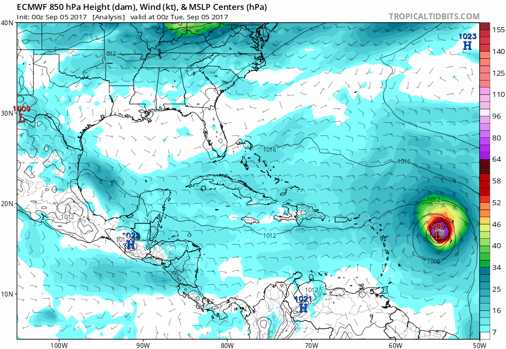
ECMWF model 0z:
The next storm to the East doesn't seem as willing to follow up Irma as it is in the GFS model.
Yeah, that's a bit weird. Still, for the "final" landfall (on Florida), I think only the extreme deepening after leaving Cuba is relevant.The pressures here look a little high? The storm is already at 939 MB and getting stronger by the hour it seems. Is the Euro anticipating some weakening or do they not have the current pressures calculated for this run?
The pressures here look a little high? The storm is already at 939 MB and getting stronger by the hour it seems. Is the Euro anticipating some weakening or do they not have the current pressures calculated for this run?
Irma looks amazing on satellite now. Would not be surprised if recon finds Cat 5 winds the next time they investigate.

Does this mean we're in for another Jeff Poiotrowski periscope?
All the new major model runs are farther west again, with the envelope after day 5 now centered on the western half of Florida. This is one savage Bermuda High.
All the new major model runs are farther west again, with the envelope after day 5 now centered on the western half of Florida. This is one savage Bermuda High.
I'm suppressing any flashbacks until at least Thursday.
We're going to need a term for the alley between Cuba and the Bahamas. Whatever it is, Irma wants to roll up straight through it.Looking more and more like a bigger Charley it seems?
It somehow holding that kind of strength together for another 5 full days while shrugging off any land on its fringes would be... well. Terrifying. I wouldn't rule anything out anymore. There are no rules anymore.I feel like Cat4 or Cat5 landfall is inevitable now, it's just a matter of where.
Looking more and more like a bigger Charley it seems?
Looking like i'll need to decide if we are getting 'out of dodge' this time around...
Charley's combination of a last minute turn, insanely fast strengthening, and crazy speed made evacuation not much of an option.
Improvements were made to the house after Charley (the total failure of the Garage Door was replaced with updated with a modern one, and additional support straps holding the roof on). But i'm still worried that a slower moving storm would cause problems beyond what the changes that were made could withstand.
I'm convinced if Charley moved at a more regular pace, the house would have been a total loss, and I might not even be around to post.
Where are you at? Tampa area I guess? I'm in East Orlando and had lots of downed trees/powerlines and without power for a while. That was about it.
That was the one good thing about Charley, it went through super fast. Very hard, but very fast. And very little rain.
You might want to give this a read then. Published several weeks ago in WaPo.
https://www.washingtonpost.com/grap...pa-bay-climate-change/?utm_term=.695895f47dfe
Here is the next frame from the GFS, soooo not good.

Whoa. No words for that.
Do the colors here indicate wind speeds?
ECMWF model 0z:
The next storm to the East doesn't seem as willing to follow up Irma as it is in the GFS model.
Recon found 929mb extrapolated.
Here is the next frame from the GFS, soooo not good.
Which is odd because Irmas CDO seems to be decaying. Probably because of the sun rise. Still looks insane on visible.Air Force recon just estimated 173 mph surface winds. This is a cat 5 now
Holy shit that's horrible
Yep, confirmed.
Well at least the eye would be offshore. Still gonna be crazy.The 06Z GFS now shows the eye remaining offshore and the storm hugging the FL east coastline all the way up.