• Hey, guest user. Hope you're enjoying NeoGAF! Have you considered registering for an account? Come join us and add your take to the daily discourse.

Atlantic Hurricane season 2017 |OT|

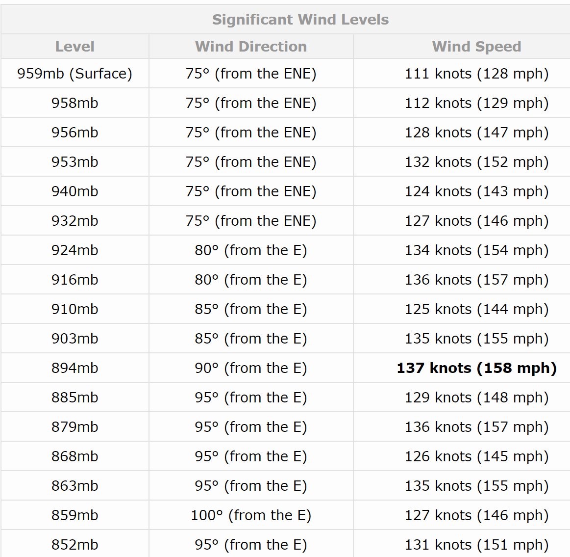
Look how close to the surface the 953 mb/152 mph wind dropsonde reading was from a recon flight (and it is outdated since surface is near 140 mph now). Might have been temporary but you can see a bunch of levels still in the 150+ mph. Winds just have to move down as it intensify's and we may see a CAT 5 by morning.

IMG_1606.JPG.639c42e82aa028ab4ed90ba9e6bc7494.JPG
 

Chumly

Member
I guess that's why the GFS takes off like a rocket once it reaches those waters. Still think it's overcooking the intensity but about 920-930 looks possible.
The GFS pressure readings are not accurate. This is widely known. It doesn't properly incorporate everything that would limit how low the pressure would get.

To reiterate DO NOT USE any pressure readings from the GFS model.
 
We had a similarly scary projection last year. I forget the storm, but it was going to go up the Florida coast, then loop around in the Atlantic and do it again. Luckily that didn't happen.

Might have been Matthew? That was the only one that really fit that possible track.
 

mo60

Member
Why can't this jerk just go spin in the ocean and end up in the desert of Africa without hurting people?

Tropical cyclones do not usally make landfall in africa especially on the western side of africa.There's really nothing that can steer a hurricane to west africa while it's in the water. The last one to affect mainland west africa directly was Delta in 2005 as an extratropical cyclone.
 
The GFS pressure readings are not accurate. This is widely known. It doesn't properly incorporate everything that would limit how low the pressure would get.

To reiterate DO NOT USE any pressure readings from the GFS model.

The GFS was also the only model that correctly projected Harvey becoming a cat. 4, about 5 days before it hit landfall, and when all other models showed it being a tropical storm/weak cat. 1 at the worst
 

mo60

Member
The GFS was also the only model that correctly projected Harvey becoming a cat. 4, about 5 days before it hit landfall, and when all other models showed it being a tropical storm/weak cat. 1 at the worst

I don't think the GFS will be that accurate in this case. It's unlikely Irma strengths to a sub 900mb hurricane in this case because environmental conditions won't be that conducive to produce a record shattering hurricane in terms of pressure and/or winds.
 

Quazar

Member
Tropical cyclones do not really make landfall in africa especially on the western side of africa.There's really nothing that can steer a hurricane to africa while it's in the water. The last one to affect mainland west africa directly was Delta in 2005 as an extratropical cyclone.

Haha this post is great.
 

Jag

Member
Look how close to the surface the 953 mb/152 mph wind dropsonde reading was from a recon flight (and it is outdated since surface is near 140 mph now). Might have been temporary but you can see a bunch of levels still in the 150+ mph. Winds just have to move down as it intensify's and we may see a CAT 5 by morning

If it is a Cat 5 so far out in the ocean, doesn't that usually mean it can't keep up that intensity before it hits land or can it sustain it all the way in?
 

Chumly

Member
wind speed and pressure are highly correlated
Please watch this video.

https://www.facebook.com/MeteorologistTimPandajis/videos/1658044980893130/

Really really good watch/listen breaking down Irma. He also goes into a bit of detail of why the GFS models are horse shit.

Or read this from Weather Underground

How strong could Irma get?
Several computer models have been confronting meteorologists with some eye-opening intensity forecasts for Hurricane Irma, especially for the period around next weekend, when Irma is currently predicted to be arcing northwest from the Eastern Bahamas. We cannot rule out the chance that Irma will reach Category 5 strength, but we can safely discount some of the most extreme model-generated intensities. The GFS global model and the new HMON regional hurricane model have consistently been deepening Irma to pressures below 900 millibars (mb). However, neither of these models fully incorporates the interaction between ocean and atmosphere that serves as a check on a hurricane's peak strength. A better guide to how strong Irma might get is the HWRF regional hurricane model, which extends out to 126 hours (just over five days). The HWRF has proven to be our most reliable model-based intensity guidance in recent years. The 0Z and 6Z Monday operational runs of HWRF deepened Irma to the 920 - 930 mb range, suggesting Irma will be a very formidable hurricane, but not a mind-blowing all-time record-setter.

For historical context, the lowest hurricane-related pressure ever measured at the surface north of the Caribbean and east of Florida is 921 mb in the Bahamas Hurricane of 1932. Hurricane Hunter dropsondes found a surface pressure of 919 mb within Hurricane Gloria (1985). Such pressures can support a Category 4 or 5 hurricane, but the peak winds depend on the size of the hurricane. As hurricanes move poleward, they typically get bigger. In a larger hurricane, the pressure force from a given central pressure will extend over a larger area, meaning that the top sustained winds will probably be lower but that a larger area could experience high winds and storm surge. This was the case with Hurricane/Superstorm Sandy, which brought record-low surface pressures and record-high surge across a large area despite winds of marginal hurricane force at best when Sandy made landfall.
Like I said Meteorologists know that the GFS model is NOT accurate when it depicts ridiculous sub 900 MB hurricanes going up florida and slamming in to the Carolinas sub 900. This doesn't mean that we won't see a category 5 hurricane. In fact its very likely that we will. It just means that we are not going to see Hurricane Patricia going up the Atlantic coast. If you want to use a model to find out the most likely intensity I would use the HWRF.
 
The official discussion has gone from "too early to say" to "remember there are large errors at day 4 and 5," which is code for "people should start paying attention now."
Tropical cyclones do not usally make landfall in africa especially on the western side of africa.There's really nothing that can steer a hurricane to west africa while it's in the water. The last one to affect mainland west africa directly was Delta in 2005 as an extratropical cyclone.
Haha this post is great.
It's accurate! That was a final exclamation mark on how ludicrous the entire 2005 season was. "Hell, one even made it to Africa!" I remember following that thing for days, wondering if it would still have any structure left at all when it got to the continent because of how absurdly rare it has to be. Can't recall what year had this fluke of a storm that popped up nearer to the UK. That was even weirder.
 

GodofWine

Member
Urg. No water left in local supermarkets already. Fuck my life.

Go to the camping section of Wal-Mart, buy water containers, fill them with tap water, freeze them. They will be drinkable and keep your freezer and fridge cold.

Freeze lots of water. It is essentially like storing energy for your refrigerator and freezer
 

Miggytronz

Member
Virginia Task Force 2 (special force rescue) is on their way to PR now. They are 200 members but only 45 are heading there as some headed to Houston to help people there. These guys are funded by the State to help many different situations affecting our great nation.
 

VanMardigan

has calmed down a bit.
Latest 11pm

030008_5day_cone_no_line_and_wind.png


Cellphones here in PR started going crazy with Hurricane warnings.

Cellphones went off here on the Virgin Islands as well. It's been pretty much heading straight west for a few readings now. Hopefully it starts ticking north soon like the models have it. If it doesn't move north by tomorrow at 11 we could be in for a direct hit. Stay safe
 

KillGore

Member
Cellphones went off here on the Virgin Islands as well. It's been pretty much heading straight west for a few readings now. Hopefully it starts ticking north soon like the models have it. If it doesn't move north by tomorrow at 11 we could be in for a direct hit. Stay safe

You too.

Sorry you guys get hit so much. PR usually manages to stay safe from these storms but the VI and other small Antilles get hit way too much.
 

Miggytronz

Member
Worried for my family in Puerto Rico with Irma soon approaching them. Stay safe and positive. I love you guys. 🇵🇷❤️
 

nillapuddin

Member
Fort Myers GAF here, just realized Irma is coming this afternoon (I don't use facebook) when my sister in Alabama called to ask me about it, welp.

yeah, all the water and flashlights were gone from Walmart and Publix, god bless poptarts tho.

stay strong Irma gaf.
 

Hex

Banned
It looks like it's not lifting upwards. It will be interesting to see if it keeps trending Southwest.

it will either eat a piece of the se coast of florida and then hook NE over land , or slingshot toward Nola /Panhandle.
Haven't had one hit here in Tampa Bay since I was a kid and that was many moons ago
 

Relix

he's Virgin Tight™
PR here. 3 24 bottles boxes of beer ready for Irma. GoPro charged... I'll try do some hurricane hunting. Depends on how close and tough she gets
 

Generate

Banned
The official discussion has gone from "too early to say" to "remember there are large errors at day 4 and 5," which is code for "people should start paying attention now."
It's accurate! That was a final exclamation mark on how ludicrous the entire 2005 season was. "Hell, one even made it to Africa!" I remember following that thing for days, wondering if it would still have any structure left at all when it got to the continent because of how absurdly rare it has to be. Can't recall what year had this fluke of a storm that popped up nearer to the UK. That was even weirder.

Vince hit Spain in 2005
Grace hit near uK in 2009
 

Vectorman

Banned
So what's the government's plan now? With Harvey having just happened, people are gonna wanna panic/take off no matter what now.
 

mo60

Member
The official discussion has gone from "too early to say" to "remember there are large errors at day 4 and 5," which is code for "people should start paying attention now."
It's accurate! That was a final exclamation mark on how ludicrous the entire 2005 season was. "Hell, one even made it to Africa!" I remember following that thing for days, wondering if it would still have any structure left at all when it got to the continent because of how absurdly rare it has to be. Can't recall what year had this fluke of a storm that popped up nearer to the UK. That was even weirder.

If I recall the tropical cyclone you are talking about is this one.
https://en.wikipedia.org/wiki/Tropical_Storm_Grace_(2009)
 

dabig2

Member
You might want to give this a read then. Published several weeks ago in WaPo.

https://www.washingtonpost.com/grap...pa-bay-climate-change/?utm_term=.695895f47dfe

Reading through that and looking at that latest GFS model...hoo boy. Shit is going to get serious.

Well, the CMC makes landfall in West Alabama. Don't know if the Canadiens ever out forecasted the others though

Wouldn't even be surprised at this point. Thing has been tracking more west on every update before that northward turn happens, so we'll see.
 
Top Bottom