• Hey, guest user. Hope you're enjoying NeoGAF! Have you considered registering for an account? Come join us and add your take to the daily discourse.

Hurricane Season 2010: Getting a jump on June 1st

Status
Not open for further replies.
It's looking strong alright, but still no circulation. However if it does circulate, it's going to be a large storm, like Alex

http://www.ssd.noaa.gov/goes/flt/t2/flash-vis-s.html

and holy shit look at all this activity!

atl_overview.gif


I don't think there was this much potential activity all of last year.
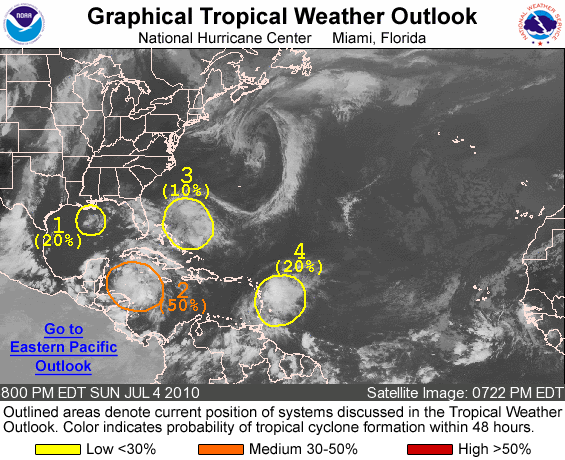
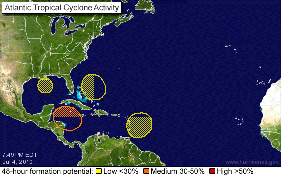
two_atl.gif


50% now
 
Screw it I'm double posting. I am starting to see circulation. you can see it here


A VIGOROUS TROPICAL DISTURBANCE LOCATED OVER THE NORTHWESTERN
CARIBBEAN SEA IS BECOMING BETTER ORGANIZED. ALTHOUGH THERE DOES NOT
APPEAR TO BE A CLOSED SURFACE CIRCULATION AT THIS TIME...NEARBY
SHIP AND BUOY OBSERVATIONS INDICATED WINDS OF TROPICAL-STORM-FORCE
BRIEFLY OCCURRED IN ASSOCIATION WITH THIS SYSTEM DURING THE PAST
FEW HOURS. ENVIRONMENTAL CONDITIONS ARE CONDUCIVE FOR DEVELOPMENT
OF THIS DISTURBANCE AS IT MOVES GENERALLY WEST-NORTHWESTWARD AT 10
TO 15 MPH...AND A TROPICAL DEPRESSION COULD DEVELOP DURING THE NEXT
COUPLE OF DAYS. THERE IS A MEDIUM CHANCE...50 PERCENT...OF THIS
SYSTEM BECOMING A TROPICAL CYCLONE DURING THE NEXT 48 HOURS.
LOCALLY HEAVY RAINFALL AND STRONG GUSTY WINDS WILL BE POSSIBLE OVER
GRAND CAYMAN ISLAND AND MUCH OF THE NORTHWESTERN CARIBBEAN SEA OVER
THE NEXT DAY OR SO.
 
From Downtown!

1. A SMALL WELL-DEFINED LOW PRESSURE SYSTEM LOCATED ABOUT 50 MILES
SOUTH-SOUTHEAST OF MORGAN CITY LOUISIANA IS MOVING ONSHORE
TERREBONNE PARISH NEAR CAILLOU BAY. DOPPLER RADAR AND SATELLITE
DATA INDICATE THAT SUSTAINED WINDS NEAR TROPICAL-STORM-FORCE COULD
OCCUR ACROSS TERREBONNE PARISH...ESPECIALLY IN TERREBONNE
BAY...LATE THIS AFTERNOON AND EARLY EVENING AS THE SYSTEM MOVES
ONSHORE. THERE IS A HIGH CHANCE...60 PERCENT...OF THIS SYSTEM
BECOMING A TROPICAL CYCLONE BEFORE IT MOVES ONSHORE. THIS SYSTEM
WILL MOVE SLOWLY NORTHWESTWARD AFTER LANDFALL AND PRODUCE LOCALLY
HEAVY RAINFALL OVER PORTIONS OF SOUTH-CENTRAL AND SOUTHEASTERN
LOUISIANA. INTERESTS SHOULD MONITOR PRODUCTS ISSUED BY THEIR LOCAL
NATIONAL WEATHER FORECAST OFFICE FOR ADDITIONAL UPDATES AND ANY
WATCHES OR WARNINGS.
atl1.gif
 
Stormwatch said:
From Downtown!

The funny thing is that on the 1pm update that system had a 0% chance of development according to the NHC. 3 hours later, it went to 60% :lol

but its so close to landfall that it won't get stronger than a very weak tropical storm at the most
 

Xeke

Banned
Stormwatch said:
From Downtown!

1. A SMALL WELL-DEFINED LOW PRESSURE SYSTEM LOCATED ABOUT 50 MILES
SOUTH-SOUTHEAST OF MORGAN CITY LOUISIANA IS MOVING ONSHORE
TERREBONNE PARISH NEAR CAILLOU BAY. DOPPLER RADAR AND SATELLITE
DATA INDICATE THAT SUSTAINED WINDS NEAR TROPICAL-STORM-FORCE COULD
OCCUR ACROSS TERREBONNE PARISH...ESPECIALLY IN TERREBONNE
BAY...LATE THIS AFTERNOON AND EARLY EVENING AS THE SYSTEM MOVES
ONSHORE. THERE IS A HIGH CHANCE...60 PERCENT...OF THIS SYSTEM
BECOMING A TROPICAL CYCLONE BEFORE IT MOVES ONSHORE. THIS SYSTEM
WILL MOVE SLOWLY NORTHWESTWARD AFTER LANDFALL AND PRODUCE LOCALLY
HEAVY RAINFALL OVER PORTIONS OF SOUTH-CENTRAL AND SOUTHEASTERN
LOUISIANA. INTERESTS SHOULD MONITOR PRODUCTS ISSUED BY THEIR LOCAL
NATIONAL WEATHER FORECAST OFFICE FOR ADDITIONAL UPDATES AND ANY
WATCHES OR WARNINGS.
atl1.gif

Out of the blue.
 
perfectchaos007 said:
The funny thing is that on the 1pm update that system had a 0% chance of development according to the NHC. 3 hours later, it went to 60% :lol

but its so close to landfall that it won't get stronger than a very weak tropical storm at the most

0% is the new 100%. Alex was 0% at one point if I remember correctly.
 

Dega

Eeny Meenie Penis
perfectchaos007 said:
The funny thing is that on the 1pm update that system had a 0% chance of development according to the NHC. 3 hours later, it went to 60% :lol

but its so close to landfall that it won't get stronger than a very weak tropical storm at the most


I thought the page had glitched or something since it was such a drastic jump in so little time. lol
 

Relix

he's Virgin Tight™
Seems like Texas is getting the first hit too.

EDIT: It's struggling atm but I am very sure in the next 8-12 hours convection is gonna blow up.
 

Hex

Banned
Smidget said:
Being a resident of FL, I prefer the crickets chirping :x

Not me.
I am from St Pete right on the west coast of florida and love when storms come through because we get the bands of wind and rain which is nice to break up the sweltering blah that is summertime in Florida (the lovely 10 months summertime)
 
Xeke said:

I wonder why all the ensemble models take it to the gulf while the NHC model takes it up the east coast. At least I assume thats the NHC model because its a white line. And hopefully it doesn't reform until after it passes Haiti. They had a earthquake this year already so they don't need a hurricane
 

Srsly

Banned
perfectchaos007 said:
I wonder why all the ensemble models take it to the gulf while the NHC model takes it up the east coast. At least I assume thats the NHC model because its a white line. And hopefully it doesn't reform until after it passes Haiti. They had a earthquake this year already so they don't need a hurricane

The white one is the official operational GFS model. All of the others are slightly tweaked versions of the operational GFS that are used to get more of a consensus with regards to the track. Personally, I'd disregard the operational model right now as it's a huge outlier.
 
Srsly said:
The white one is the official operational GFS model. All of the others are slightly tweaked versions of the operational GFS that are used to get more of a consensus with regards to the track. Personally, I'd disregard the operational model right now as it's a huge outlier.

Yeah thats strange though because usually the main GFS model is somewhere in the center of the GP1-20 models. Thats just so strange to see it as an outlier. well, disregarding that then if this thing forms, look out BP oil spill region!!
 
I arrive in Orlando on Sunday morning. Maybe I should cancel my convertible rental car ;). Depending on the model it looks like it might be out in the Gulf by then, though.
 
Duane Cunningham said:
I'll be in the Bahamas for a week at the beginning of September for my honeymoon. I hope planning that trip was a good decision.

Is it a cruise? You're already gonna be rockin the boat so a hurricane won't stop that motion of the ocean
 
Duane Cunningham said:
:lol :lol :lol

Nope, just flying down and staying in a hotel on the beach.

nice. Atlantis? I was there last year. THey have a real fun waterpark and then beautiful beaches. Nice honeymoon destination imo. Also the Miss Universe pageant was going on while I was there. But you're on your honeymoon so you couldn't get distracted like I was.
 

NH Apache

Banned
Time to pack the car with the good old emergency trunk just in case. Only the most probable line seems to want to go through New Orleans. Yay.
 

Relix

he's Virgin Tight™
It's quite probable as TS is in formation at this point, and seeing the steering layers... close call for Miami then the Gulf. Florida could see a strong Tropical Storm or Cat 1 Hurricane.
 
Relix said:
Fucking thing has taken a liking to PR and will just not lift off from here :lol

My local station has already said it has dumped 8 inches in PR. And it looks like the center of circulation started to move toward the DR and then backtracked back toward PR. Is there a tropical magnent in PR? :lol
 

Relix

he's Virgin Tight™
perfectchaos007 said:
My local station has already said it has dumped 8 inches in PR. And it looks like the center of circulation started to move toward the DR and then backtracked back toward PR. Is there a tropical magnent in PR? :lol

Who the fuck knows :lol , I went out in a business trip and in my way back all the rain and stormy weather caught me off guard. I check my Weather Channel app and alas... whole island is being dumped upon. Center is relocation to the NW peak of PR a few miles of Aguadillas, which is causing all that convection and weather to affect us directly again and even more stronger. Will be a bitch. Someone already died here messing around with a river.
 
ZCZC MIATWOAT ALL
TTAA00 KNHC DDHHMM
TROPICAL WEATHER OUTLOOK
NWS TPC/NATIONAL HURRICANE CENTER MIAMI FL
200 AM EDT WED JUL 21 2010

FOR THE NORTH ATLANTIC...CARIBBEAN SEA AND THE GULF OF MEXICO...

1. A STRONG TROPICAL WAVE...LOCATED NEAR THE EASTERN DOMINICAN REPUBLIC
AND EXTENDING NORTHWARD OVER THE ATLANTIC FOR A FEW HUNDRED
MILES...IS PRODUCING A LARGE AREA OF SHOWERS AND THUNDERSTORMS FROM
THE NORTHERN LEEWARD ISLANDS WESTWARD TO HISPANIOLA...AND OVER THE
ADJACENT WATERS OF THE ATLANTIC AND NORTHEASTERN CARIBBEAN SEA.
ALTHOUGH A CLOSED SURFACE CIRCULATION HAS NOT YET DEVELOPED...
ENVIRONMENTAL CONDITIONS ARE EXPECTED TO BECOME MORE CONDUCIVE FOR
TROPICAL CYCLONE FORMATION AS THE SYSTEM MOVES WEST-NORTHWESTWARD
AT ABOUT 10 MPH DURING THE NEXT DAY OR SO. THERE IS A HIGH
CHANCE...70 PERCENT...OF THIS SYSTEM BECOMING A TROPICAL DEPRESSION
OR A TROPICAL STORM DURING THE NEXT 48 HOURS. REGARDLESS OF
DEVELOPMENT...LOCALLY HEAVY RAINFALL AND GUSTY WINDS WILL CONTINUE
TO AFFECT THE VIRGIN ISLANDS AND PUERTO RICO...AND LIKELY AFFECT
THE DOMINICAN REPUBLIC...HAITI...EASTERN CUBA...THE TURKS AND
CAICOS ISLANDS...AND THE BAHAMAS DURING THE NEXT COUPLE OF DAYS.
THE HEAVY RAINS COULD CAUSE LIFE-THREATENING FLASH FLOODS AND MUD
SLIDES IN MOUNTAINOUS AREAS.


ELSEWHERE...TROPICAL CYCLONE FORMATION IS NOT EXPECTED DURING THE
NEXT 48 HOURS.


Poor Poor Haiti. Isn't an earthquake enough tragedy for one year?
 
perfectchaos007 said:
nice. Atlantis? I was there last year. THey have a real fun waterpark and then beautiful beaches. Nice honeymoon destination imo. Also the Miss Universe pageant was going on while I was there. But you're on your honeymoon so you couldn't get distracted like I was.

No, just the Hyatt in Nassau. We've kind of scouted out some of the stuff around there and there's some snorkeling and glass bottom kayaks and stuff that cost a fortune that I'll probably pay for anyway.
 
Status
Not open for further replies.
Top Bottom