-
Hey, guest user. Hope you're enjoying NeoGAF! Have you considered registering for an account? Come join us and add your take to the daily discourse.
You are using an out of date browser. It may not display this or other websites correctly.
You should upgrade or use an alternative browser.
You should upgrade or use an alternative browser.
Hurricane Season 2010: Getting a jump on June 1st
- Thread starter Xeke
- Start date
- Status
- Not open for further replies.
Dead Prince
Banned
a friend posted this yesterday. Poor PR :lol

Dead Prince
Banned
Mayaguez area probably.
they even posted a video :lol.
they even posted a video :lol.
perfectchaos007
Member
Well looks like it's gonna fizzle.
INVEST 97L/TROPICAL DEPRESSION 3
FLORIDA WATCH COMING
. VISIBLE SATELLITE IMAGES AND OBSERVATIONS FROM THE BAHAMAS INDICATE
THAT THE AREA OF LOW PRESSURE IN THE SOUTHEASTERN BAHAMAS HAS
BECOME BETTER ORGANIZED AND A CLOSED CIRCULATION HAS FORMED.
ADVISORIES ON A TROPICAL DEPRESSION OR A TROPICAL STORM WILL BE
INITIATED AT 11 AM EDT...1500 UTC TODAY. THIS ADVISORY WILL LIKELY
INCLUDE TROPICAL STORM WATCHES AND WARNINGS FOR PORTIONS OF THE
BAHAMAS AND SOUTHERN FLORIDA.
(Auto Updates)


(Auto Update)


FLORIDA WATCH COMING
. VISIBLE SATELLITE IMAGES AND OBSERVATIONS FROM THE BAHAMAS INDICATE
THAT THE AREA OF LOW PRESSURE IN THE SOUTHEASTERN BAHAMAS HAS
BECOME BETTER ORGANIZED AND A CLOSED CIRCULATION HAS FORMED.
ADVISORIES ON A TROPICAL DEPRESSION OR A TROPICAL STORM WILL BE
INITIATED AT 11 AM EDT...1500 UTC TODAY. THIS ADVISORY WILL LIKELY
INCLUDE TROPICAL STORM WATCHES AND WARNINGS FOR PORTIONS OF THE
BAHAMAS AND SOUTHERN FLORIDA.
(Auto Updates)
(Auto Update)
Personal Opinion about TD3 and definitively TS Bonnie:
The models are initialiting a bit south from where the actual COC is. The HWRF model looks likely but definitely a bit more west. Then in the GOM most models agree with the recurvature so Louisiana and New Orleans gotta watch out. The system will get stronger once it reaches the GOM as there are few inhibiting factors at the moment.
For Florida: A 50mph Tropical Storm seems likely.
For the Gulf Coast: A Hurricane will definitely be in the books. A major is unlikely unless upper level winds get calmer.
By the way, it seems the Oil Spill will be hit by Bonnie.
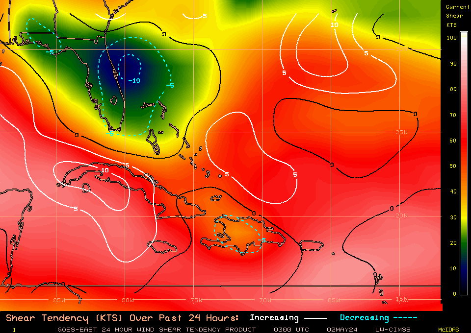
Shear map shows the 15-20kts of shear around the storm but decreasing all around it and with a comfortable batch ahead which will allow for more intensification but nothing too great. Same shear levels continue all the way into the gulf.
Shear map shows the 15-20kts of shear around the storm but decreasing all around it and with a comfortable batch ahead which will allow for more intensification but nothing too great. Same shear levels continue all the way into the gulf.
TD3 Declared:

000
WTNT33 KNHC 221459
TCPAT3
BULLETIN
TROPICAL DEPRESSION THREE ADVISORY NUMBER 1
NWS TPC/NATIONAL HURRICANE CENTER MIAMI FL AL032010
1100 AM EDT THU JUL 22 2010
...TROPICAL DEPRESSION FORMS IN THE BAHAMAS...AIR FORCE
RECONNAISSANCE PLANE EN ROUTE...
SUMMARY OF 1100 AM EDT...1500 UTC...INFORMATION
-----------------------------------------------
LOCATION...21.9N 75.0W
ABOUT 265 MI...425 KM SE OF NASSAU
ABOUT 405 MI...655 KM ESE OF KEY LARGO FLORIDA
MAXIMUM SUSTAINED WINDS...35 MPH...55 KM/HR
PRESENT MOVEMENT...WNW OR 295 DEGREES AT 15 MPH...24 KM/HR
MINIMUM CENTRAL PRESSURE...1008 MB...29.77 INCHES
WATCHES AND WARNINGS
--------------------
CHANGES WITH THIS ADVISORY...
THE GOVERNMENT OF THE BAHAMAS HAS ISSUED A TROPICAL STORM WARNING
FOR THE CENTRAL AND NORTHWESTERN BAHAMAS.
A TROPICAL STORM WARNING HAS BEEN ISSUED FOR THE FLORIDA EAST COAST
FROM GOLDEN BEACH SOUTHWARD INCLUDING THE ENTIRE FLORIDA KEYS AND
FLORIDA BAY...AND ALONG THE WEST COAST OF FLORIDA NORTHWARD TO
BONITA BEACH.
A TROPICAL STORM WATCH HAS BEEN ISSUED FOR THE EAST COAST OF FLORIDA
FROM NORTH OF GOLDEN BEACH TO JUPITER INLET INCLUDING LAKE
OKEECHOBEE.
SUMMARY OF WATCHES AND WARNINGS IN EFFECT...
A TROPICAL STORM WARNING IS IN EFFECT FOR...
* CENTRAL AND NORTHWESTERN BAHAMAS
* FOR THE FLORIDA EAST COAST FROM GOLDEN BEACH SOUTHWARD INCLUDING
THE ENTIRE FLORIDA KEYS AND FLORIDA BAY...AND ALONG THE WEST COAST
OF FLORIDA NORTHWARD TO BONITA BEACH
A TROPICAL STORM WATCH IN IN EFFECT FOR...
* THE EAST COAST OF FLORIDA NORTH OF GOLDEN BEACH TO JUPITER INLET
INCLUDING LAKE OKEECHOBEE
A TROPICAL STORM WARNING MEANS THAT TROPICAL STORM CONDITIONS ARE
EXPECTED SOMEWHERE WITHIN THE WARNING AREA WITHIN 36 HOURS.
A TROPICAL STORM WATCH MEANS THAT TROPICAL STORM CONDITIONS ARE
POSSIBLE WITHIN THE WATCH AREA...GENERALLY WITHIN 48 HOURS.
FOR STORM INFORMATION SPECIFIC TO YOUR AREA IN THE UNITED
STATES...INCLUDING POSSIBLE INLAND WATCHES AND WARNINGS...PLEASE
MONITOR PRODUCTS ISSUED BY YOUR LOCAL NATIONAL WEATHER SERVICE
FORECAST OFFICE. FOR STORM INFORMATION SPECIFIC TO YOUR AREA OUTSIDE
UNITED STATES...PLEASE MONITOR PRODUCTS ISSUED BY YOUR NATIONAL
METEOROLOGICAL SERVICE.
DISCUSSION AND 48-HOUR OUTLOOK
------------------------------
AT 1100 AM EDT...1500 UTC...THE CENTER OF NEWLY FORMED TROPICAL
DEPRESSION THREE WAS LOCATED NEAR LATITUDE 21.9 NORTH...LONGITUDE
75.0 WEST. THE DEPRESSION IS MOVING TOWARD THE WEST-NORTHWEST NEAR
15 MPH...24 KM/HR. THIS GENERAL MOTION WITH AN INCREASE IN FORWARD
SPEED IS EXPECTED DURING THE NEXT 48 HOURS.
MAXIMUM SUSTAINED WINDS ARE NEAR 35 MPH...55 KM/HR...WITH HIGHER
GUSTS. THE DEPRESSION COULD BECOME A TROPICAL STORM LATER TODAY.
ESTIMATED MINIMUM CENTRAL PRESSURE IS 1008 MB...29.77 INCHES.
HAZARDS AFFECTING LAND
----------------------
WIND...WINDS NEAR TROPICAL STORM FORCE ARE ALREADY AFFECTING
PORTIONS OF THE SOUTHEASTERN BAHAMAS. TROPICAL STORM CONDITIONS
WILL GRADUALLY SPREAD OVER THE CENTRAL AND NORTHWESTERN BAHAMAS
TONIGHT AND FRIDAY. WEATHER CONDITIONS WILL BEGIN TO DETERIORATE ON
THE FLORIDA COAST AND FLORIDA KEYS WITHIN THE WARNING AREA ON
FRIDAY.
RAINFALL...THE DEPRESSION IS EXPECTED TO PRODUCE TOTAL RAIN
ACCUMULATIONS OF OF 2 TO 4 INCHES OVER SOUTH FLORIDA...WITH
POSSIBLE ISOLATED MAXIMUM AMOUNTS OF 5 TO 6 INCHES. RAINFALL
AMOUNTS OF 3 TO 5 INCHES ARE EXPECTED OVER THE CENTRAL AND
NORTHWEST BAHAMAS...WITH POSSIBLE ISOLATED AMOUNTS OF 5 TO 7
INCHES.
STORM SURGE...STORM SURGE WILL RAISE WATER LEVELS BY AS MUCH AS 1 TO
2 FEET ABOVE GROUND LEVEL OVER PORTIONS OF THE BAHAMAS AND THE
FLORIDA KEYS.
NEXT ADVISORY
-------------
NEXT INTERMEDIATE ADVISORY...200 PM EDT.
NEXT COMPLETE ADVISORY...500 PM EDT.
$$
FORECASTER AVILA/ROBERTS
dskillzhtown
keep your strippers out of my American football
I guess I will be missing work on Monday. Time to buy some batteries and canned goods!!!
perfectchaos007
Member
So NHC doesn't think its going to reach hurricane status. I think it will if it shifts more south toward texas
perfectchaos007 said:So NHC doesn't think its going to reach hurricane status. I think it will if it shifts more south toward texas
If I remember correctly they didn't have Alex reaching Hurricane status either. As Relix said earlier in the thread, they're usually conservative with their estimates.
We officially have Bonnie
000
WTNT63 KNHC 222214
TCUAT3
TROPICAL DEPRESSION THREE TROPICAL CYCLONE UPDATE
NWS TPC/NATIONAL HURRICANE CENTER MIAMI FL AL032010
615 PM EDT THU JUL 22 2010
...DEPRESSION BECOMES TROPICAL STORM BONNIE...
DATA FROM AN AIR FORCE HURRICANE HUNTER RECONNAISSANCE AIRCRAFT
DURING THE PAST HOUR INDICATE THAT SURFACE WINDS ASSOCIATED WITH
THE DEPRESSION HAVE INCREASED TO 40 MPH...65 KM/HR...AND THAT THE
DEPRESSION HAS BECOME A TROPICAL STORM.
SUMMARY OF 615 PM EDT...2215 UTC...INFORMATION
--------------------------------------------------
LOCATION...22.9N 75.4W
ABOUT 200 MI...320 KM SE OF NASSAU
ABOUT 415 MI...670 KM ESE OF KEY WEST FLORIDA
MAXIMUM SUSTAINED WINDS...40 MPH...65 KM/HR
PRESENT MOVEMENT...NW OR 315 DEGREES AT 14 MPH...22 KM/HR
MINIMUM CENTRAL PRESSURE...1005 MB...29.68 INCHES
$$
FORECASTER KIMBERLAIN/BEVEN
Srsly said:Jindal has already declared a state of emergency for LA...
Well that was quick:lol
Srsly said:Bonnie looking rather healthy right now and i wouldn't be surprised if it made a run at reaching hurricane status before striking Florida.
Yeah it's been organizing quickly.
Srsly said:Jindal has already declared a state of emergency for LA...
FFFUUUUUUUUUUU
Well, time to go stock up.
Dead Prince
Banned
Srsly.Srsly said:Jindal has already declared a state of emergency for LA...
and I live in Baton Rouge. Let's see how things play out :lol
Dead Prince
Banned
NOOOOOOO. strengthen baby. i want a day off.
perfectchaos007
Member
the wave in the lower antilles looks large. if that does form into a depression it could be big
Relix said:Invest 90L is far more dangerous, trust me ;-)
It's time for a Cape Verde Hurricane.
Relix said:90L "died" but just because it was absorbed by a tropical wave. The future 91L invest already has a healthy spin and if it keeps it's track little dry air or SAL intrusion. Looks like a classic cape verde storm.
perfectchaos007
Member
Relix said:90L "died" but just because it was absorbed by a tropical wave. The future 91L invest already has a healthy spin and if it keeps it's track little dry air or SAL intrusion. Looks like a classic cape verde storm.
Just a few more hours till August so it's right on schedule! And half the models have it going to PR so good luck Relix! lol
perfectchaos007 said:Just a few more hours till August so it's right on schedule! And half the models have it going to PR so good luck Relix! lol
It all depends on how long it takes to really form a well definied system. The stronger it is the more northerly component they have. Poleward movement and all that stuff. Of course that's unless a strong High blocks the path.
Also, models are in a frenzy. They don't really have a center to initialize from so they are just going by estimates. As soon as we have an actual closed low they get a better grip. Especially the European model. Not worried at the moment but really paying attention to it.
lunarworks
Member
What exactly is the nomenclature of the name "Invest 91L".
The 91 part is obvious, but I don't quite understand the other parts.
The 91 part is obvious, but I don't quite understand the other parts.
lunarworks said:What exactly is the nomenclature of the name "Invest 91L".
The 91 part is obvious, but I don't quite understand the other parts.
Invest:
A weather system for which a tropical cyclone forecast center (NHC, CPHC, or JTWC) is interested in collecting specialized data sets (e.g., microwave imagery) and/or running model guidance. Once a system has been designated as an invest, data collection and processing is initiated on a number of government and academic web sites, including the Naval Research Laboratory (NRL) and the University of Wisconsin Cooperative Institute for Meteorological Satellite Studies (UW-CIMSS). The designation of a system as an invest does not correspond to any particular likelihood of development of the system into a tropical cyclone; operational products such as the Tropical Weather Outlook or the JTWC/TCFA should be consulted for this purpose.
L is the code for the Atlantic if I remember correctly.
Edit: source http://www.nhc.noaa.gov/aboutgloss.shtml
perfectchaos007
Member
Relix said:It all depends on how long it takes to really form a well definied system. The stronger it is the more northerly component they have. Poleward movement and all that stuff. Of course that's unless a strong High blocks the path.
Also, models are in a frenzy. They don't really have a center to initialize from so they are just going by estimates. As soon as we have an actual closed low they get a better grip. Especially the European model. Not worried at the moment but really paying attention to it.
yep, now its forecasted to take the North Atlantic Drift and only effect Bermuda. Thats what happens when they are forecasted to drift north of PR.
Invest 91L is about to become our next TD and surely, TS Colin. Interest in the Greater Antilles, PR (lol i am screwed) and the Bahamas have to keep an eye on the storm. Right now what it hit, what it misses, if it recurves, if it goes into the Gulf... it's all timing. There's a weakness in the ridge caused by a through that should form around 65W that will pull the system up. After that models say it will recurve, others for the Carolinas.
My 2 cents... it's a big system and it's taking its time to form a surface circulation. They feel the effects a little less. The ridge was pushed sightly west last night too. I think the system will pass over the Greater Antilles, maybe a very close call or over me in PR as a Cat 1 Hurricane. I can see it going over the northern Bahamas and reaching the Carolinas by Saturday or Sunday as a Cat 1. A TUTT will cause shear on the system though it has an anticyclone. Let's see what nature wants to do
My 2 cents... it's a big system and it's taking its time to form a surface circulation. They feel the effects a little less. The ridge was pushed sightly west last night too. I think the system will pass over the Greater Antilles, maybe a very close call or over me in PR as a Cat 1 Hurricane. I can see it going over the northern Bahamas and reaching the Carolinas by Saturday or Sunday as a Cat 1. A TUTT will cause shear on the system though it has an anticyclone. Let's see what nature wants to do
TD04
ALL IMAGES AUTO UPDATE. Save if you want to keep a history.


(these models are suspect as of August 2. They are already off so let's wait for new runs)
Update August 2: As of 9:30PM EST you can see very good outflow and spin. It's a compact system but at the same time huge. Has a big moisture field. Some dry air is noted ahead int he Water Vapor but shouldn't be deterimental. As the days go the system will surely grow in size. Remember that the bigger they are the longer they take to form and organize.
ALL IMAGES AUTO UPDATE. Save if you want to keep a history.
(these models are suspect as of August 2. They are already off so let's wait for new runs)
Update August 2: As of 9:30PM EST you can see very good outflow and spin. It's a compact system but at the same time huge. Has a big moisture field. Some dry air is noted ahead int he Water Vapor but shouldn't be deterimental. As the days go the system will surely grow in size. Remember that the bigger they are the longer they take to form and organize.

perfectchaos007
Member
Well they don't want the Carolinas to panic just yet. You know how the NHC is....
perfectchaos007
Member
Colin is going going GONE! lol okay it may regenerate like you said. But that new wave south of PR looks favorable for development.
Dead Prince
Banned
there must be something wrong. when is a hurricane going to hit us!
DMPrince said:there must be something wrong. when is a hurricane going to hit us!
I am eagerly awaiting that :lol
Colin seems to be back at TS status. NHC has sent a plane to investigate. They said that it isn't a tropical storm but you can see the freaking COC out of the convection. That's a LLC. It has 40mph+ winds. It is a tropical storm. Why NHC hasn't called it yet have no idea.
ITCZ disturbance in the CATL should move NW out of the Antilles area, then pushed back by ridge and moved to West. Think an Andrews-type track. Fully expect it to recurve after the ridge push.
Wave coming off Africa has potential as there won't be any weaknesses in the ridge by then. Should aim at Antilles and Caribbean.
92L in the Caribbean looks bad, it has circulation, but moving too fast and will soon face land interaction.
perfectchaos007
Member
yep it's a bermuda storm!
- Status
- Not open for further replies.