• Hey, guest user. Hope you're enjoying NeoGAF! Have you considered registering for an account? Come join us and add your take to the daily discourse.

Hurricane Season 2016 |OT|

Status
Not open for further replies.

Relix

he's Virgin Tight™
Hurricane Season 2016 has started with three systems already down the list, and is expected to be an above normal season. Our names are:

Alex
Bonnie
Colin
Danielle
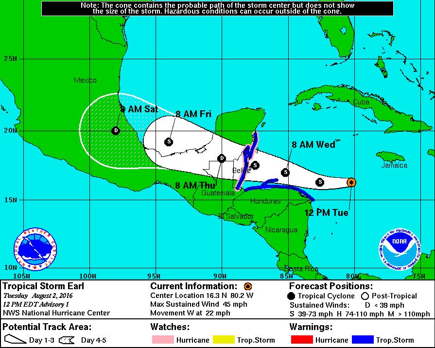
Earl
Fiona
Gaston
Hermine

Ian
Julia
Karl
Lisa
Matthew
Nicole
Otto
Paula
Richard
Shary
Tobias
Virginie
Walter
 
Was wondering when this thread was going to be made. Better late than never!
This is also the earliest we have ever gotten to a "C" storm in any hurricane season.
But the NHC projects an average year....
 

Relix

he's Virgin Tight™
Active Systems:

Hermine
153730W5_NL_sm.gif
 

Relix

he's Virgin Tight™
Was wondering when this thread was going to be made. Better late than never!
This is also the earliest we have ever gotten to a "C" storm in any hurricane season.
But the NHC projects an average year....


Yeah I've been too busy, thought somebody had done it but nope. But here it is and hey... a nice storm heading to Florida for a change of pace!
 

mo60

Member
Was wondering when this thread was going to be made. Better late than never!
This is also the earliest we have ever gotten to a "C" storm in any hurricane season.
But the NHC projects an average year....

You can thank Hurricane Alex for that.If he did not form in the middle of January we probably wouldn't have the third named storm of the year in early June.
 
You can thank Hurricane Alex for that.If he did not form in the middle of January we probably wouldn't have the third named storm of the year in early June.

No doubt. That was totally arbitrarily tacked on to this season due to the calendar year, but I would have tacked it on to the 2015 season since it formed closer to the 2015 hurricane season than 2016' season
 
July was completely silent in the Atlantic, but the Pacific was quite active. Generally means the Atlantic could have a busy August. Lo and behold a couple of waves formed off Cape Verde and could become tropical depressions right around the start of August

two_atl_0d0.png
 
1. A strong tropical wave over the central Caribbean Sea, centered
about 275 miles east-southeast of Kingston, Jamaica, continues to
move quickly westward at about 20 mph. Thunderstorm activity
associated with the wave remains organized, but the system still
appears to lack a closed surface circulation. Environmental
conditions are expected to be conducive for additional development,
and a tropical storm is likely to form later today or tonight. An
Air Force Reserve Reconnaissance aircraft is currently en route to
investigate this system late this afternoon. Regardless of
development, locally heavy rainfall and gusty winds, perhaps to
tropical storm force, will continue over portions of the Dominican
Republic and Haiti through this evening. Tropical storm conditions
are likely to occur over Jamaica by this evening, and could reach
the Cayman Islands overnight. Interests in these areas and
elsewhere in the western Caribbean Sea should continue to monitor
the progress of this disturbance. For additional information, see
High Seas Forecasts issued by the National Weather Service.

* Formation chance through 48 hours...high...80 percent
* Formation chance through 5 days...high...90 percent

5BOQxTb.png
 
It has been a fairly quiet.... decade... for Hurricanes it seems.

I remember it use to be storm after storm year after year and everyone was blaming global warning.

Then... nothing.
 
It has been a fairly quiet.... decade... for Hurricanes it seems.

I remember it use to be storm after storm year after year and everyone was blaming global warning.

Then... nothing.
It has been almost 4 years since a hurricane has been in the gulf. The longest streak without a hurricane in the gulf since the 1800s.
 
Looks like the road near the house is flooded. More than likely the neighborhood is flooded
Now we are leaving the friends house because water is coming this way.
 
From what I heard the house on another street is flooded near the roof. So most likely our place is gone. Hopefully not. Road closure so we won't know
 

TomServo

Junior Member
It's a long way off but we should keep an eye on 99L

CqRRdnsXgAAg6jP.jpg

This season I checked and restocked my hurricane supplies, test fired my generator, filled my gas cans with ethanol-free gasoline, and paid a lot of money to have some large trees removed or trimmed back away from the house.

I'm as ready as it gets. Which means nothing will come near the east coast of Florida.
 

Vaux

Member
I'm probably the only one that hopes that a hurricane comes our way every year. Its fucking hot in Texas.
 
The cool air on the other side is nice, but if you lose power for more than a few days it gets damn nasty.

ugh. brings back nightmares from Ike. some of the businesses got power back before my residence and I would spend most of the day sitting inside a fastfood joint to get out of the 95 degree house. Unfortunately I couldn't sleep at Burger King so I had to eventually go home and sleep in my 90 degree bed
 

MrJames

Member
Yeah, 99L will stay weak for a while but the models are developing it as it nears the Bahamas. 90L looks to become a major but should thankfully stay out at sea.
 
Still worth keeping an eye on Invest 99l.

Latest Euro model run is showing it crossing Florida as a strong Tropical Storm / low end Cat 1 Hurricane and rapidly deepening in the Gulf and recurving back to hit Big Bend as a Major Hurricane.

Still a week or so away and intensity is the most difficult thing for the models to estimate.

HL0KRh7.png

Storm systems that hit florida, then wrap around and hit florida again aren't uncommon historically. Ivan's path has always made me chuckle

at200409.gif
 

MrJames

Member
Still worth keeping an eye on Invest 99l.

Latest Euro model run is showing it crossing Florida as a strong Tropical Storm / low end Cat 1 Hurricane and rapidly deepening in the Gulf and recurving back to hit Big Bend as a Major Hurricane.

Still a week or so away and intensity is the most difficult thing for the models to estimate.

HL0KRh7.png

A hit like that into a low lying area there would probably change the coastline.
 
Latest Euro just out. Landfall as a Cat 1 in the Miami region, strengthens as it crosses southern Florida. Rapidly deepens in the Gulf into a Major Hurricane and makes landfall around Mobile Bay at a catastrophic intensity of around 935mb.

Thankfully it's just a model and the thing isn't even a tropical depression yet but the Euro has been consistent in developing this for 3 runs now. Keep a close eye on it just in case...

lksdCvP.gif
 
Latest Euro just out. Landfall as a Cat 1 in the Miami region, strengthens as it crosses southern Florida. Rapidly deepens in the Gulf into a Major Hurricane and makes landfall around Mobile Bay at a catastrophic intensity of around 935mb.

Thankfully it's just a model and the thing isn't even a tropical depression yet but the Euro has been consistent in developing this for 3 runs now. Keep an close eye on it...

lksdCvP.gif

Just the rainfall could be pretty catastrophic for Louisiana.
 
Latest Euro just out. Landfall as a Cat 1 in the Miami region, strengthens as it crosses southern Florida. Rapidly deepens in the Gulf into a Major Hurricane and makes landfall around Mobile Bay at a catastrophic intensity of around 935mb.

Thankfully it's just a model and the thing isn't even a tropical depression yet but the Euro has been consistent in developing this for 3 runs now. Keep a close eye on it just in case...

lksdCvP.gif

The 2nd landfall point keeps shifting further west in the Euro model. I think the longer it takes for 99L to form, the further west it will track. If it develops ahead of schedule then it will make that northerly turn earlier and may only brush the florida eastern coast
 
The 2nd landfall point keeps shifting further west in the Euro model. I think the longer it takes for 99L to form, the further west it will track. If it develops ahead of schedule then it will make that northerly turn earlier and may only brush the florida eastern coast

The Euro develops a strong ridge which forces it westward. It only begins to turn north after deepening to a strong hurricane in the Gulf. I doubt it will be get strong enough to turn poleward without the assistance of a trough before reaching Florida but intensity is the hardest part to forecast.
 
Status
Not open for further replies.
Top Bottom