perfectchaos007
Member
TD in the gulf now
This could be good for texansperfectchaos007 said:TD in the gulf now
Relix said:
ZROCOOL said:This could be good for texans
NihonTiger90 said:It's looking more like it could be the bastard son of TS Allison for Louisiana.
Yeah I was looking at that now. Disappointed i amNihonTiger90 said:It's looking more like it could be the bastard son of TS Allison for Louisiana.
Goddamnit, that's like drought-ending rain for us. Fuck you, Louisiana we called it first.06nbarnhill said:Yup MSNBC is reporting 10-20 inches of rain possible

Smiles and Cries said:
that one pink line going to the Great Lakes
XD
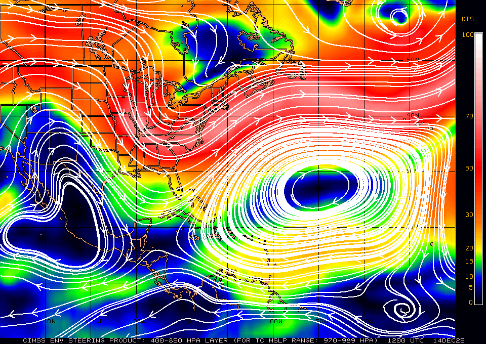
That high pressure system has been there for days and given us very lovely weather ever since Irene blew through.NihonTiger90 said:Do my eyes deceive me, or is there now a high pressure system parked in the middle of the western Atlantic? That doesn't seem very good if that's where Katia was supposed to be making her turn at because now she'll have to navigate that as well.
DOO13ER said:Goddamnit, that's like drought-ending rain for us. Fuck you, Louisiana we called it first.
LOCK said:There still might be hope for Texas. Pray to God, mother nature, or whoever that it heads that way.
DOO13ER said:Can someone with more weather savvy than me explain why they think Lee will hang a hard right into Lousiana? Shouldn't high pressure be keeping it mostly on its north westernly track?


LOCK said:There still might be hope for Texas. Pray to God, mother nature, or whoever that it heads that way.
At which point the world will end anyway, so who cares!dskillzhtown said:I doubt we will get any real rain until 2012.
Le fucking SIGH!MooMoo said:Katia, stay the hell away from east coast >:[
AbsoluteZero said:
Oh son of a crap.
Edit: New Orleans is going to look like a lake come Monday morning.
Geez, that thing is moving sloooooooooooooow.AbsoluteZero said:http://icons-ecast.wunderground.com/data/images/at201113_5day.gif
Oh son of a crap.
Edit: New Orleans is going to look like a lake come Monday morning.
Mikasangelos said:yeah as slow as its moving the South is gonna be miserable for the next few days. Expect flooding everywhere.
BigJonsson said:At least its not Katia hitting NOLA?
AbsoluteZero said:I dunno, I think I'd prefer it, since it's moving along at a faster clip, it won't sit in one spot and just dump rain on us for like three or four days straight. The pumps in New Orleans won't be able to keep up.
Mikasangelos said:
I say by Monday we will see where this thing is gonna head. Right now.............its too wobbly and unorganized to know where its heading.Gamecocks625 said:Still projected to head back out to sea? Because that track freaks me out (SC resident here).
Tropical Depression Thirteen formed last night over the Northern Gulf of Mexico and is slowly intensifying, but isn't in a hurry to go anywhere. What TD 13 will do is dump torrential rains along the northern Gulf Coast over the next three or more days. So far, rain amounts along the coast have mostly been below one inch.
Hurricane Katia is continuing its long trek across the Atlantic Ocean today, and will not pose a danger to any land areas over the next five days. Katia is still struggling with dry air and moderate wind shear of 10 - 20 knots. Latest satellite loops show surface-based arc-shaped clouds racing to the southwest away from Katia's core, a sign that dry air is penetrating into Katia's thunderstorms and creating strong downdrafts that are robbing the storm of heat and moisture. Katia is over warm ocean waters of 28.5°C, and these waters will increase in temperature to 29°C over the next five days. Katia will pass well north of the region of cooler waters stirred up by the passage of Hurricane Irene last week.
The models are split on when the upper-level trough of low pressure bringing the wind shear to Katia will move away, and the storm may spend two more days battling wind shear and dry air before the upper-level trough pulls away to the north and allows Katia to intensify more readily. It is still unclear how much of a threat Katia may pose to the U.S., but it is becoming increasingly clear that Katia will pass uncomfortably close to the U.S. East Coast. The trough of low pressure currently steering Katia to the northwest will lift out early next week, and a ridge of high pressure is expected to build in, forcing Katia more to the west. This decreases the danger to Bermuda, but increases the danger to the U.S. A second trough of low pressure is expected to begin affecting Katia by the middle of next week, and will potentially recurve the storm out to sea before it hits the U.S.
AbsoluteZero said:
Oh son of a crap.
Edit: New Orleans is going to look like a lake come Monday morning.
http://answers.yahoo.com/question/index?qid=20080830131306AAMKmDrmckmas8808 said:What does Minimum pressure mean when it comes to these hurricanes?
NH Apache said:I'm Bartending in the fq this weekend. I think we may have to close sunday and Monday. Shit is gonna get crazy. 20 inches of rain with hurricane winds sunday. Yeah, I'm outtie.
so basically Katia is probably going to hit the east coast and depending on how fast it curves back out to sea it could drill new york/new england, or am i just completely reading this wrong?Mikasangelos said:http://www.wunderground.com/blog/JeffMasters/article.html?entrynum=1913
zmoney said:so basically Katia is probably going to hit the east coast and depending on how fast it curves back out to sea it could drill new york/new england, or am i just completely reading this wrong?
Gotcha...will keep an eye out. thanks for the update.Mikasangelos said:If a High builds in the atlantic its very likely its gonna hit the east cost, how? nobody knows. Right now it looks like its not taking a solid northerly track at all and B lining towards NC/VA. So we'll see by weekends end to see where it is.