-
Hey, guest user. Hope you're enjoying NeoGAF! Have you considered registering for an account? Come join us and add your take to the daily discourse.
You are using an out of date browser. It may not display this or other websites correctly.
You should upgrade or use an alternative browser.
You should upgrade or use an alternative browser.
Atlantic Hurricane season 2017 |OT|
- Thread starter perfectchaos007
- Start date
Miggytronz
Member

My cousin in PR is ready. Some of my family will go to his house for safety and comfort during the storm.
maabus1999
Member
If I were in PR, I would be hightailing it to the southwest side of the island pronto.
Why? All of Puerto Rico is in the cone still so there is no guaranteed best place. Best is to go to shelters in high elevations away from the coast if you need to evacuate.
perfectchaos007
Member
Why? All of Puerto Rico is in the cone still so there is no guaranteed best place. Best is to go to shelters in high elevations away from the coast if you need to evacuate.
Tracks can change, but it has been creeping north ever so slightly for the past 24 hours.Right now I would bet my safety on the southwest side of the island. A bit inland of course, like San German
You should not be following a single model. NHC forecasts are best. They take into account all the modelsWhere can you go to see the latest Euro track? All the American sites still seem to just use the garbage American one.
Tracks can change, but it has been creeping north ever so slightly for the past 24 hours.Right now I would bet my safety on the southwest side of the island. A bit inland of course, like San German
And you'll be avoiding the dangerous NE quadrant of the hurricane.
You should not be following a single model. NHC forecasts are best. They take into account all the models
Especially for this one as models are going to be all over the place for the next few days as we watch drunk Jose do whatever up north. That storm is a large variable on the trajectory of Maria.
maabus1999
Member
Tracks can change, but it has been creeping north ever so slightly for the past 24 hours.Right now I would bet my safety on the southwest side of the island. A bit inland of course, like San German
Radar track is showing she is faster than the models currently (more west) and currently has a more westerly component then anything. I would say this put more southern Puerto Rico in play vs North. Here is where Maria is supposed to be 2 hours from now. You can see Maria is well to the SW of the position 2 hours in advance. Euro and CMC had her similarly north also.

Gamecocks625
Member
Especially for this one as models are going to be all over the place for the next few days as we watch drunk Jose do whatever up north. That storm is a large variable on the trajectory of Maria.
in what way?
superdeluxe
Member
24 hours ago this wasn't a hurricane and now cat 5.
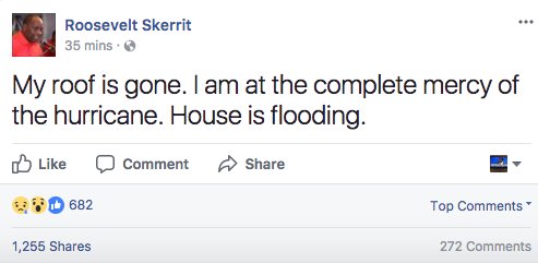
https://www.facebook.com/SupportRooseveltSkerrit/
Insane. The Prime Minister had to be rescued from his own home.
Insane. The Prime Minister had to be rescued from his own home.
Jose can help direct Maria out into the Atlantic.. or disappate and open the cone for another US landfall.in what way?
superdeluxe
Member
Dead Prince
Banned
WTF already cat 5?
Lady Vengeance.
Even coastal towns like Aguada are fairly mountainous and elevated.Tracks can change, but it has been creeping north ever so slightly for the past 24 hours.Right now I would bet my safety on the southwest side of the island. A bit inland of course, like San German
We are safe from storm surge and flooding in Aguadilla, outside of downtown Aguadilla which is at a much lower elevation than the rest of town. We also don't have any major rivers. My biggest concern, and I think most people's over here, is the wind.
maabus1999
Member
Please remember high elevation is also not good in a Hurricane as the winds get exceptionally stronger in altitude, so hillsides can be the worse spot for wind damage.
Recon already found 190 mph winds several hundred feet above the surface...
Recon already found 190 mph winds several hundred feet above the surface...
in what way?
Here's a weather article on it I was reading yesterday:
https://weather.com/storms/hurricane/news/hurricane-maria-steering-interaction-jose
If Jose stalls as the majority of the forecast guidance suggest, it will temporarily block an area of high pressure over the eastern U.S. from moving farther east. If that high were able to build east faster, it would likely send Maria on a more west-northwest path.
Instead, Maria will gain latitude in between that eastern U.S. high-pressure system and another area of high pressure located to Maria's east in the Atlantic Ocean.

There's another side to this Jose and Maria story where an interaction between the systems called the Fujiwhara effect could occur.
Named for a Japanese researcher who discovered this in experiments with water in the early 1920s, the Fujiwhara effect details how two tropical cyclones 800 to 900 miles apart rotate counter-clockwise about one another.
"Think of the teacup ride at Disney or the Tilt-a-Whirl at your local county fair, but with tropical systems instead," says weather.com senior meteorologist Jonathan Erdman.
The animation to the right shows an example of the Fujiwhara effect this past July in the western Pacific Ocean. A much weaker Tropical Storm Kulap pivoted westward around the northern periphery of a stronger Typhoon Noru as the two systems interacted.
If this Fujiwhara interaction between Jose and Maria did take place, a weakened Jose could get slung back west towards the East Coast around the northern periphery of Maria. Then Maria would get launched out to sea.
A Fujiwhara effect would be the most interesting. Maria would be flung out to sea as Jose gets launched back to the east coast. This would honestly probably work out better for us as Jose is already weak as hell and in colder waters and wouldn't threaten the coast that much even if it does get bounced back. Maria is the clear more dangerous threat.
But this will all be for naught if Jose dissipates into nothing over the next couple days and right now that storm is looking ragged as hell. Supposedly it got sheared to oblivion earlier.
BlazinSkatinAxel
Member
That's really bad. Dominica is going to get hit really hard in the next hour.
This thing looks like Sonic.... This storm was just a Cat 1?!!

Maria's rapid growth is crazy.
The EarthWindMap continues to be a fantastic visualization.
https://earth.nullschool.net/#current/wind/surface/level/orthographic=-60.62,15.98,3000
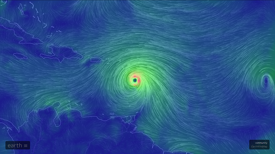
The EarthWindMap continues to be a fantastic visualization.
https://earth.nullschool.net/#current/wind/surface/level/orthographic=-60.62,15.98,3000
Really not in the place to get into this shit again.
Can someone just tell me how quickly it's moving and when it makes sense to check in on it from FL? (Thurs?Fri?)
Once it passes Puerto Rico, start paying close attention.
Gamecocks625
Member
This is incredibly fascinating. I shouldn't have failed out of meteorology in college haHere's a weather article on it I was reading yesterday:
https://weather.com/storms/hurricane/news/hurricane-maria-steering-interaction-jose
A Fujiwhara effect would be the most interesting. Maria would be flung out to sea as Jose gets launched back to the east coast. This would honestly probably work out better for us as Jose is already weak as hell and in colder waters and wouldn't threaten the coast that much even if it does get bounced back. Maria is the clear more dangerous threat.
But this will all be for naught if Jose dissipates into nothing over the next couple days and right now that storm is looking ragged as hell. Supposedly it got sheared to oblivion earlier.
Insane Metal
Member
Maria's rapid growth is crazy.
The EarthWindMap continues to be a fantastic visualization.
https://earth.nullschool.net/#current/wind/surface/level/orthographic=-60.62,15.98,3000
So, uh... is that another freaking storm just behind Maria? What the hell?
maabus1999
Member
So, uh... is that another freaking storm just behind Maria? What the hell?
That is Lee, which is about to disappear. No worries there.
On that note, Jose looks like he is being ripped apart by shear. Not much left of the core after the last hour.
That is Lee, which is about to disappear. No worries there.
On that note, Jose looks like he is being ripped apart by shear. Not much left of the core after the last hour.
Also, Jose is still tropical according to the recon aircraft even though it has some extratropical features right now.

Models show shear dropping quickly tommorrow which may allow Jose to restrengthen.I rather wait and see what happens with jose but I still do not think jose is going away for while even though it may not be tropical by the end of the week.
aspiegamer
Member
That pressure hike of almost 20 while moving over land is interesting given it had just dropped more than that in the previous few hours. The inner core went right over the mountains of the island which I can see being messy for a storm this compact. The total delta in 6 hours would be more than 50mb! And it's started going back down again immediately!
Have there been any other observed instances like this? This was a fluke that the aircraft caught it just before and just after.
Edit: With the wobble north a lot of Guadeloupe is in the radius of hurricane force winds, and there's a town of ~45,000 on the south coast that is probably in trouble. So Maria is making a point of damaging as many islands Irma felt like sparing as possible.
5am update from NHC with a line drawn by me on top.

I'm the second blue dot. Looking pretty good, I'm confident that it'll miss us by a good bit, but we're very reliant on that northward turn after Puerto Rico being accurate. In my experience, though, having lived here so much of my life, that northwards turn is usually pretty reliable. It's the westwardly moving storms that start further north like Ike and Irma that tend to hit us.
It's close enough that people are going to remain nervous here, though.
mentallyinept
Banned
5am update from NHC with a line drawn by me on top.
I'm the second blue dot. Looking pretty good, I'm confident that it'll miss us by a good bit, but we're very reliant on that northward turn after Puerto Rico being accurate. In my experience, though, having lived here so much of my life, that northwards turn is usually pretty reliable. It's the westwardly moving storms that start further north like Ike and Irma that tend to hit us.
It's close enough that people are going to remain nervous here, though.
Here's hoping you get through OK, man.
mingoguaya
Member
I'm hoping this is the case but now the storm will enter the Caribbean Sea's hot water and it should slow down and gain some momentum and lower its trajectory again. I hope I'm very wrong about this.Exiting through Dorado/Toa Baja. Every new forecast gets a little easier on us in the west. I hope to God there's still a chance it misses the island entirely.
24 hours ago this wasn't a hurricane and now cat 5.
I was gonna say... I just heard about Maria for the first time on the news this morning... like wtf?
I can't believe Jose is still a hurricane.
I feel like people have been calling for his death for days now and he just chugs on like a zombie.
Apparently him being alive is a good thing. Pulls on Maria a bit.
Smiles and Cries
Member
For first time in 300 years, no one is living on Barbuda
http://www.cnn.com/2017/09/15/americas/irma-barbuda-population-trnd/index.html
that is crazy
http://www.cnn.com/2017/09/15/americas/irma-barbuda-population-trnd/index.html
that is crazy
For first time in 300 years, no one is living on Barbuda
http://www.cnn.com/2017/09/15/americas/irma-barbuda-population-trnd/index.html
that is crazy
Population of nearly 100,000 displaced... mental
No, that's the population of the country. 'Only' 1,800 people lived on Barbuda.Population of nearly 100,000 displaced... mental
perfectchaos007
Member
Radar is showing she is faster than the models currently (more west) and currently has a more westerly component then anything. I would say this put more southern Puerto Rico in play vs North. Here is where Maria is supposed to be 2 hours from now. You can see Maria is well to the SW of the position 2 hours in advance. Euro and CMC had her similarly north also.
Looks like its still creeping more and more north. Might make landfall on the northeast side of PR. I would still evacuate to the southwest side of the island.
maabus1999
Member
Looks like its still creeping more and more north. Might make landfall on the northeast side of PR. I would still evacuate to the southwest side of the island.
NHC still thinks south coast landfall as of 11 am. Also looking at actual position vs forecast and models, Maria continues to be SW of the forecast track.
That happened to us during Irma. Our early plans would have taken us to an area that actually experienced the eye of the storm. The last minute turn meant we were in a comparatively much safer area.Why? All of Puerto Rico is in the cone still so there is no guaranteed best place. Best is to go to shelters in high elevations away from the coast if you need to evacuate.
Full disclosure where we stayed would have been safe from just about anything.
It looks like Jose may be starting to restrengthen again.
Jose doesn't look to bad right now compared to yesterday.

The NHC's latest advisory expects that most of Jose's circulation should still be over warm water a few days from now which should help fuel the storm even though it's center will be over 21 degrees celsius water.
Latest track forecast for Jose.

Jose doesn't look to bad right now compared to yesterday.
The NHC's latest advisory expects that most of Jose's circulation should still be over warm water a few days from now which should help fuel the storm even though it's center will be over 21 degrees celsius water.
Latest track forecast for Jose.
maabus1999
Member
It looks like Jose may be starting to restrengthen again.
Jose doesn't look to bad right now compared to yesterday.
The NHC's latest advisory expects that most of Jose's circulation should still be over warm water a few days from now which should help fuel the storm even though it's center will be over 21 degrees celsius water.
Latest track forecast for Jose.
She is borderline sub tropical according to NHC 11 am; warm core keeps her tropical but the overall pattern is shifting quickly to extra tropical with how the circulation is wrapping.
StopMakingSense
Member
nm
maabus1999
Member
The latest GFS run has Jose strengthening and then doing another loop.
Can someone just kill this fucker?
Jose actually gets absorbed by Maria; looks like a high is going to block a full turn OTS. Seems to be drifting.
Only thing to take away from this long term since it will be way off on track is if Jose either dies early or is absorbed, it doesn't leave a low for Maria to easily escape which increases landfall odds.