-
Hey, guest user. Hope you're enjoying NeoGAF! Have you considered registering for an account? Come join us and add your take to the daily discourse.
You are using an out of date browser. It may not display this or other websites correctly.
You should upgrade or use an alternative browser.
You should upgrade or use an alternative browser.
Atlantic Hurricane season 2017 |OT|
- Thread starter perfectchaos007
- Start date
Thankfully no one seems too keen on making the storm anything other than a low-end hurricane/tropical storm with the exception of HMON which has it at around 959 MB on hitting the US mainland. This would likely be a mid-range category 2.
It's one to watch though as storms forming in that area can bomb very quickly. There's plenty of hot water for it.
It's one to watch though as storms forming in that area can bomb very quickly. There's plenty of hot water for it.
maabus1999
Member
God fucking dammit. I swear if that thing comes this way (nola) I'm going to flip my shit.

All, this storm is sitting around 90% chance to become a storm soon and will have 3+ days over the gulf before it hits. Due to surface temps and low sheer, when this thing forms and if it does miss a Yucatan hit, "Nate" may bomb out like Harvey did intensity wise.
Over the next 48 hours, I would recommend watching the NHC tracks on this development.
Thankfully no one seems too keen on making the storm anything other than a low-end hurricane/tropical storm with the exception of HMON which has it at around 959 MB on hitting the US mainland. This would likely be a mid-range category 2.
It's one to watch though as storms forming in that area can bomb very quickly. There's plenty of hot water for it.
Do not rely on intensity models until a core is formed; they are inaccurate at this stage. Plus with the La Nina effect going on, expect a much higher probability of it being stronger than weaker than forecast (see Harvey). La Nina is not factored very well into models...
perfectchaos007
Member
All, this storm is sitting around 90% chance to become a storm soon and will have 3+ days over the gulf before it hits. Due to surface temps and low sheer, when this thing forms and if it does miss a Yucatan hit, "Nate" may bomb out like Harvey did intensity wise.
Over the next 48 hours, I would recommend watching the NHC tracks on this development.
Do not rely on intensity models until a core is formed; they are inaccurate at this stage. Plus with the La Nina effect going on, expect a much higher probability of it being stronger than weaker than forecast (see Harvey). La Nina is not factored very well into models...
Interesting. NHC has landfall east of all of those points. NHC is showing landfall near Tallahassee Florida
That is pretty much exactly where the current Euro model (today 0z) puts it as well:Interesting. NHC has landfall east of all of those points. NHC is showing landfall near Tallahassee Florida

Landfall would be on 2017-10-08 (sunday) at 1800 UTC / 2 PM EDT.
Though currently, the same model predicts that it gets pretty windy, but nothing more:
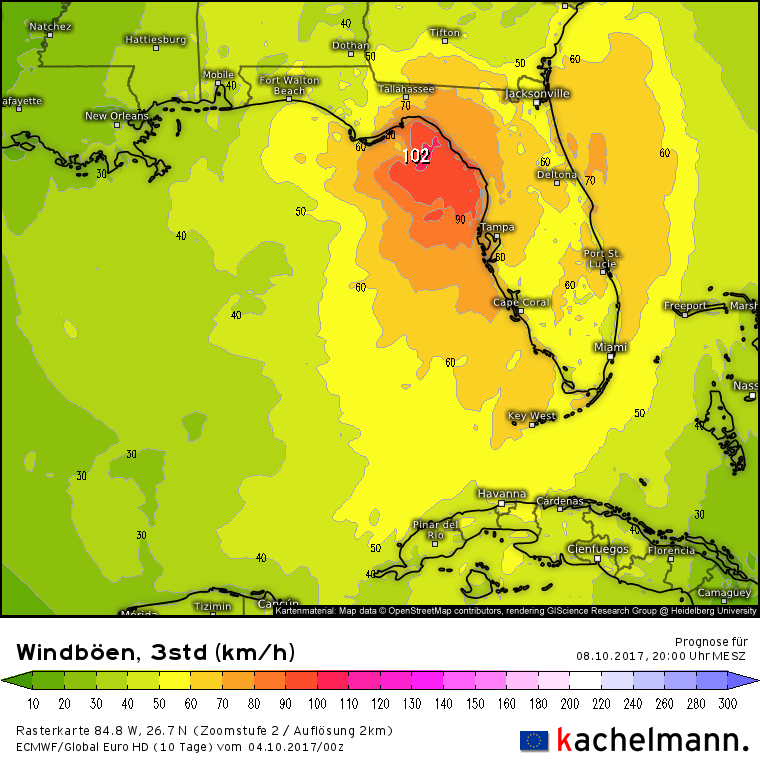
Those are wind gusts at around 100 km/h ≈ 60 mph
We got a live one!
000
WTNT31 KNHC 041438
TCPAT1
BULLETIN
Tropical Depression Sixteen Advisory Number 1
NWS National Hurricane Center Miami FL AL162017
1100 AM EDT Wed Oct 04 2017
...NEW DEPRESSION FORMS IN THE SOUTHWESTERN CARIBBEAN SEA...
...TROPICAL STORM WARNING ISSUED FOR PARTS OF CENTRAL AMERICA...
SUMMARY OF 1100 AM EDT...1500 UTC...INFORMATION
-----------------------------------------------
LOCATION...12.2N 81.9W
ABOUT 25 MI...40 KM SSW OF SAN ANDRES ISLAND
ABOUT 210 MI...340 KM SSE OF CABO GRACIAS A DIOS ON NIC/HON BORDER
MAXIMUM SUSTAINED WINDS...35 MPH...55 KM/H
PRESENT MOVEMENT...NW OR 305 DEGREES AT 7 MPH...11 KM/H
MINIMUM CENTRAL PRESSURE...1005 MB...29.68 INCHES
WATCHES AND WARNINGS
--------------------
CHANGES WITH THIS ADVISORY:
The government of Nicaragua has issued a Tropical Storm Warning for
the coast of Nicaragua from Sandy Bay Sirpi northward to the
Honduras border.
The government of Honduras has issued a Tropical Storm Warning for
the coast of Honduras from Punta Castilla eastward to the
border with Nicaragua.
SUMMARY OF WATCHES AND WARNINGS IN EFFECT:
A Tropical Storm Warning is in effect for...
* Sandy Bay Sirpi Nicaragua to Punta Castilla Honduras
A Tropical Storm Warning means that tropical storm conditions are
expected somewhere within the warning area, in this case within 24
hours.
Interests elsewhere in Honduras, the Bay Islands, western Cuba and
the Yucatan Peninsula should monitor the progress of the depression.
For storm information specific to your area, please monitor
products issued by your national meteorological service.
DISCUSSION AND 48-HOUR OUTLOOK
------------------------------
At 1100 AM EDT (1500 UTC), the center of Tropical Depression Sixteen
was located near latitude 12.2 North, longitude 81.9 West. The
depression is moving toward the northwest near 7 mph (11 km/h) and
this motion is expected to continue today. On the forecast track,
the depression should be nearing the coast of Nicaragua early
Thursday, move across northeastern Nicaragua and eastern Honduras
late Thursday, and emerge into the northwestern Caribbean Sea on
Friday.
Maximum sustained winds are near 35 mph (55 km/h) with higher gusts.
The depression is expected to become a tropical storm later today
or tonight.
The estimated minimum central pressure is 1005 mb (29.68 inches).
HAZARDS AFFECTING LAND
----------------------
RAINFALL: Rainfall amounts of 15 to 20 inches are expected across
portions of Nicaragua, with isolated maximum amounts of 30 inches
possible. Across Costa Rica and Panama, 5 to 10 inches of rain are
expected, with isolated maximum totals of around 20 inches possible.
Across Honduras, rainfall amounts of 2 to 5 inches, with isolated
maximum amounts of 8 inches are expected. This rainfall could cause
life-threatening flash floods and mudslides.
WIND: Tropical storm conditions are expected to start in the
warning area in Nicaragua early on Thursday, and spread into
Honduras late Thursday.
NEXT ADVISORY
-------------
Next intermediate advisory at 200 PM EDT.
Next complete advisory at 500 PM EDT.
$$
Forecaster Blake
Smiles and Cries
Member
Gulf Season has begun?
perfectchaos007
Member
This is gulf season part two. Part one was in June. The good news for the Texas coast line is most storms that form in the latter half of gulf season tend to get pushed East due to continuous fall fronts that push throughGulf Season has begun?
Master Yoshi
Member
Here we go again... Again.
Vestal
Gold Member
Very interesting video explaining why such a huge discrepancy between the GFS and Euro models. How tomorrow we will probably get much more clarity as to were this might be headed for landfall and what areas need to keep watch..
https://youtu.be/UiJ0KfgQxAA
https://youtu.be/UiJ0KfgQxAA
Smiles and Cries
Member
Nate huh
The current Euro model has put SIXTEEN's path decidedly further west. Here are the ensemble storm tracks:
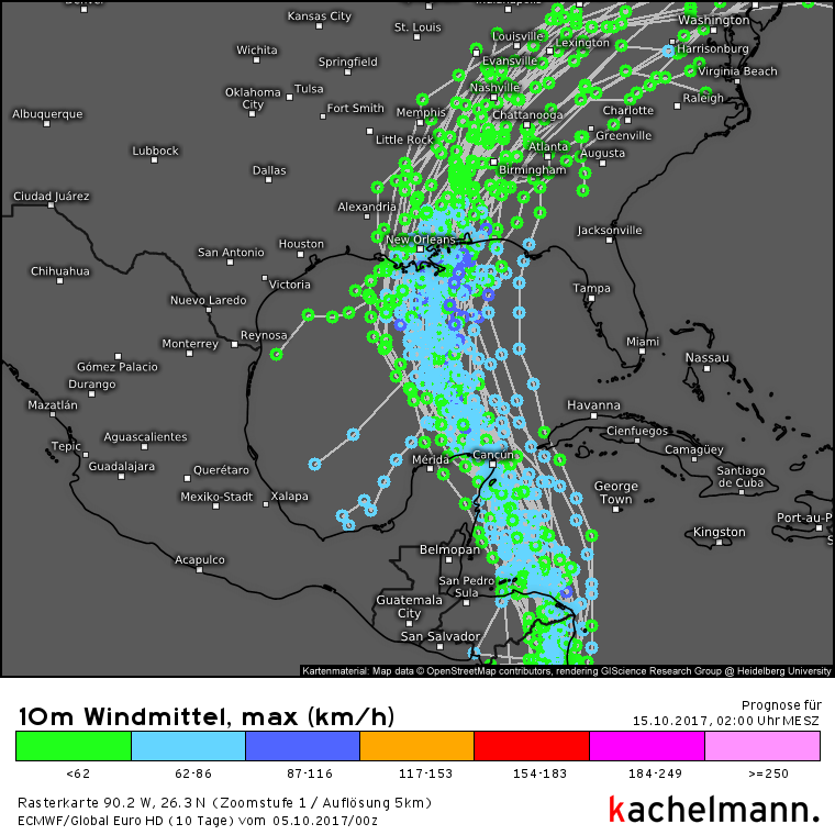
Going right through Mississippi. Lovely...

Captain Tuttle
Member
What are the water temperatures like in The Gulf?
The Sum of Zero
Member
Going right through Mississippi. Lovely...
And Alabama. Not fun.
What are the water temperatures like in The Gulf?
Mid 80's
perfectchaos007
Member
Looks like a landfall between Slidell LA and Gulfport MS. Right where Katrina made landfall
Current (12z) Euro model ensemble storm tracks:
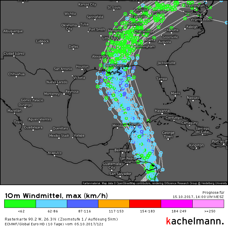
Note that the wind speeds are probably wrong, at least the NHC has it a bit higher. Orange is where hurricane force begins, the light blue most of the tracks are in corresponds to 38-53 mph.
Closer look at where Nate makes landfall according to the main run:

Landfall is on 8 October (Sunday) at 0900 UTC or 5 AM EDT.
Note that the wind speeds are probably wrong, at least the NHC has it a bit higher. Orange is where hurricane force begins, the light blue most of the tracks are in corresponds to 38-53 mph.
Closer look at where Nate makes landfall according to the main run:
Landfall is on 8 October (Sunday) at 0900 UTC or 5 AM EDT.
captjohnboyd
Member
Well new Orleans has declared a state of emergency. That escalated fast. I worked extra shifts all week to bolster the paycheck and now we may be closed all weekend. Ugh
Smiles and Cries
Member
Does not seem to hold that H long so might be weak when it hits?
Randolph Freelander
Member
Its forecast is to be a weak hurricane, but Harvey went from nothing to a Cat 4 in short time in the gulf, and two days out from landfall, it wasn't even forecasted to become a hurricane.
http://www.nhc.noaa.gov/archive/2017/al09/al092017.discus.012.shtml?
People along the gulf coast should make no assumptions.
http://www.nhc.noaa.gov/archive/2017/al09/al092017.discus.012.shtml?
People along the gulf coast should make no assumptions.
StopMakingSense
Member
The NHC seems very confident with that narrow cone too. Stay safe guys!
Wow that cone is TIGHT. Never seen that.
They uh...they fixed those levees right?
The levees are fixed, just dont ask about the pumps...
Wow that cone is TIGHT. Never seen that.
Because models are in agreement.

maabus1999
Member
Recon has already measured steep pressure drops starting and satellite is starting to show a strong circular convection. It is most likely that Nate will be a hurricane in the coming hours and is already exceeding by a wide margin the models in intensity. Chance for Rapid intensification is still very high.
Green Yoshi
Member
Mayor Mitch Landrieu declared a state of emergency Thursday (Oct. 5) in advance of Tropical Storm, which is forecast to strengthen into a hurricane by the time it impacts the Gulf Coast.
"To the citizens of New Orleans, there is no reason to panic, but there is reason to prepare," Landrieu said.
http://www.nola.com/hurricane/index.ssf/2017/10/tropical_storm_nate_sewerage_w.html
So for Nate up here in ATL what should I be expecting? Looks like some bad winds mainly?
Or, maybe really bad wind and rain. Bleh.
https://www.accuweather.com/en/us/stone-mountain-ga/30083/weather-warnings/337724
...TROPICAL WEATHER CONDITIONS POSSIBLE LATE SATURDAY NIGHT INTO
SUNDAY ACROSS NORTH AND CENTRAL GEORGIA...
Tropical Storm Nate, currently just east of the Yucatan
penninsula of Mexico, is expected to track north-northwest across
the Gulf of Mexico through Saturday, making landfall somewhere
along the central Gulf Coast Saturday night.
The latest track from the National Hurricane Center has Nate
turning northeast across Alabama, approaching northwest Georgia by
Sunday afternoon. Based on this current forecast track, the
probability of seeing tropical storm-force wind gusts, greater
than 40 MPH, is increasing across portions of central and north
Georgia throughout Sunday. Several hours of winds of this
magnitude would be capable of bringing down trees and powerlines.
In addition to the wind, periods of heavy rain could produce 2 to
6 inches of rainfall which may result in localized flash flooding,
especially across urban and poor drainage areas. A few tornadoes
are also possible within any of the more organized rain bands that
are associated with Nate.
As forecast confidence increases overnight tonight into Saturday,
Tropical Storm Watches may be issued for portions of central and
north Georgia.
This is an evolving and challenging forecast. Please stay tuned
to the latest forecasts and information from the National
Hurricane Center, and the National Weather Service in Peachtree
City.
Or, maybe really bad wind and rain. Bleh.
https://www.accuweather.com/en/us/stone-mountain-ga/30083/weather-warnings/337724
At least Nate is moving very quickly compared to the others.
I have no doubt they have been working very hard, but happy to see even more trucks making the rounds on Irma cleanup duty just in case. There was an abundance of debris still laying around, but the prudent thing is to get as much of it out of the way as possible just in case.
I have no doubt they have been working very hard, but happy to see even more trucks making the rounds on Irma cleanup duty just in case. There was an abundance of debris still laying around, but the prudent thing is to get as much of it out of the way as possible just in case.
The Sum of Zero
Member
Looks like we'll be getting this in Alabama on Sunday. At least I'll be on the northwest part of it.
4pm update:
4pm update:

Not too worried about the wind, but we put up metal shields on the windows anyway. Way more worried about the flooding. If the current track and rainfall hold steady, our first floor will flood. Going to move everything that I can upstairs tomorrow.
Current model says it'll make landfall over Ocean Springs, MS. Not looking forward too it.
Current model says it'll make landfall over Ocean Springs, MS. Not looking forward too it.
The Sum of Zero
Member
Dead Prince
Banned
Hopefully it shifts more east. Don't want the storm
Randolph Freelander
Member
Just upgraded to a hurricane.
http://www.nhc.noaa.gov/text/refresh/MIATCUAT1+shtml/DDHHMM.shtml
http://www.nhc.noaa.gov/text/refresh/MIATCUAT1+shtml/DDHHMM.shtml
Hurricane Nate Tropical Cyclone Update
NWS National Hurricane Center Miami FL AL162017
1030 PM CDT Fri Oct 06 2017
...NATE BECOMES A HURRICANE...
An Air Force Reserve Hurricane Hunter aircraft just penetrated the
center of Nate and reported hurricane-force winds. The maximum
winds are estimated to be 75 mph (120 km/h) with higher gusts.
Pagusas
Elden Member
So my wife and I are on the Cruise Ship Liberty of the Seas right now in the Gulf on the last few days of a 7 day cruise. We were suppose to stop in Cozumel but Nate caused our captain to skip the stop, push the boat to full throttle and get 110 notical miles of space between us and it. Right now we safe and Im not worried about it causing us too many issue, the captain has cut back the throttle and given us an extra day at sea in place of the missed stopped, basically going to coast into Galveston for a Sunday morning docking.
Smiles and Cries
Member
this thing did not leave us any time for guessing games at all with landfall coming up so soon
even the paths agree so weird
stay safe Gulf-GAF
Was just wondering. This is old info and based on general Atlantic trends which may differ from Gulf storms, but still.
Forward speed of Atlantic hurricanes averaged by 5 degree Latitude Speed
20°-25°N ||| 17.5 km/hr |9.4 knt |10.8 mph |8602 cases
The most recent update on, Nate.
23.5 N @ 22MPH
Forward speed of Atlantic hurricanes averaged by 5 degree Latitude Speed
20°-25°N ||| 17.5 km/hr |9.4 knt |10.8 mph |8602 cases
The most recent update on, Nate.
23.5 N @ 22MPH
Looks like Biloxi will get it now.
We have about 50,000 tourists in town. The curfew will now be enforced, it's only an attempt to keep the streets clear. Some rstaurants will be staying open. Most bars will be open. Most gigs have been cancelled.
Edit: *not be enforced